Okoneshnikovo geodata
Okoneshnikovo (Omsk) is a populated place; located in Russia in Asia/Omsk (GMT+6) time zone. With population of 5,501 people, there are 2438 cities with bigger population in this country. Compared to other cities in Russia, 51.5% of cities are located further ↓South; 78.3% of cities are located further ←West and 67.2% of cities have higher elevation than Okoneshnikovo. Note1


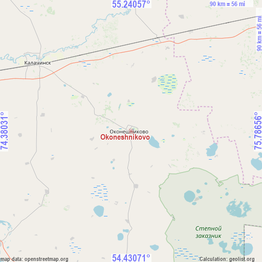
Okoneshnikovo GPS coordinates[2]
54° 50' 15.612" North, 75° 5' 0.348" East
| Map corner | latitude | longitude |
|---|---|---|
| Upper-left | 55.24057°, | 74.38031° |
| Center: | 54.83767°, | 75.08343° |
| Lower-right: | 54.43071°, | 75.78656° |
| Map W x H: | 90×90 km | = 55.9×55.9mi |
| max Lat: | 73.50819° ⇑48.5% North |
| Okoneshnikovo: | 54.83767° |
| min Lat: | ⇓51.5% South 41.28413° |
| min Long | Okoneshnikovo | max Long |
| -179.12198° | 75.08343° | 179.35046° |
| W 78.3%⇐ | ⇒21.7% E |
Elevation
Elevation of Okoneshnikovo is 109 m = 358 ft, and this is 93.6 m = 307 ft below average elevation for this country.
| Max E: |
2518 m = 8261 ft | 67.2% |
| Avg. | 202.6 m = 665 ft | |
| Okoneshnikovo | 109 m = 358 ft | |
Min E: |
-28 m = -92 ft | 32.8% |
See also: Russia elevation on elevation.city.
Geographical zone
Okoneshnikovo is located in North temperate zone (between Tropic of Cancer and the Arctic Circle). Distance of this North polar circle is 1303.8 km =810.1 mi to North.| Distance of | km | miles | from Okoneshnikovo |
|---|---|---|---|
| North Pole | 3909.7 | 2429.4 | to North |
| Arctic Circle | 1303.8 | 810.1 | to North |
| Tropic Cancer | 3491.5 | 2169.5 | to South |
| Equator | 6097.4 | 3788.7 | to South |


Nearby cities:
15 places around Okoneshnikovo: (largest is in red/bold)
• Beregovoy
124.5 km =77.4 mi,  287°
287°
• Chany
119.3 km =74.1 mi,  63°
63°
• Cherlak
78 km =48.5 mi,  193°
193°
• Irtyshskiy
95.9 km =59.6 mi,  268°
268°
• Kalachinsk
40.3 km =25 mi,  306°
306°
• Kormilovka
65.3 km =40.6 mi, 286°
• Nizhnyaya Omka
66.9 km =41.6 mi,  352°
352°
• Novoomskiy
114.1 km =70.9 mi, 270°
• Novovarshavka
78.1 km =48.5 mi,  198°
198°
• Omsk
110.9 km =68.9 mi,  278°
278°
• Pavlogradka
121.1 km =75.2 mi,  234°
234°
• Tatarsk
71.3 km =44.3 mi,  53°
53°
• Tavricheskoye
96.9 km =60.2 mi,  253°
253°
• Ust’-Tarka
90.2 km =56 mi,  25°
25°
• Vkhodnoy
122.9 km =76.4 mi, 275°
Sources, notices
• [Note1] Compared only with cities in Russia existing in our database
• [Src1] Map data: © OpenStreetMap contributors (CC-BY-SA)
• [Src2] Other city data from geonames.org with taken over terms of usage.
• [Src3] Geographical zone / Annual Mean Temperature by Robert A. Rohde @ Wikipedia
