Kormilovka geodata
Kormilovka (Omsk) is a populated place; located in Russia in Asia/Omsk (GMT+6) time zone. With population of 10,166 people, there are 1486 cities with bigger population in this country. Compared to other cities in Russia, 53.3% of cities are located further ↓South; 78% of cities are located further ←West and 67.7% of cities have higher elevation than Kormilovka. Note1


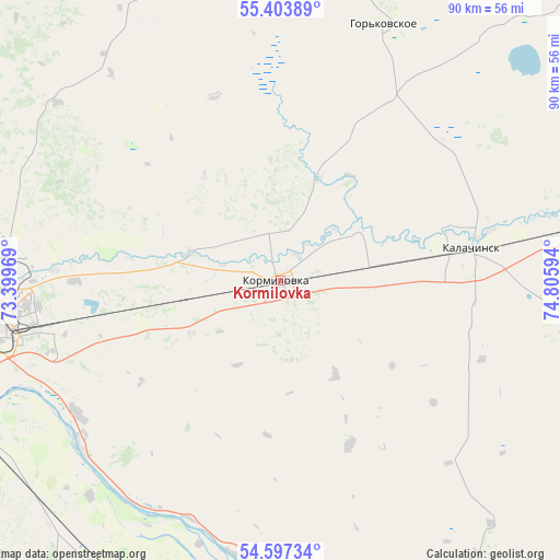
Kormilovka GPS coordinates[2]
55° 0' 9.504" North, 74° 6' 10.116" East
| Map corner | latitude | longitude |
|---|---|---|
| Upper-left | 55.40389°, | 73.39969° |
| Center: | 55.00264°, | 74.10281° |
| Lower-right: | 54.59734°, | 74.80594° |
| Map W x H: | 89.7×89.7 km | = 55.7×55.7mi |
| max Lat: | 73.50819° ⇑46.7% North |
| Kormilovka: | 55.00264° |
| min Lat: | ⇓53.3% South 41.28413° |
| min Long | Kormilovka | max Long |
| -179.12198° | 74.10281° | 179.35046° |
| W 78%⇐ | ⇒22% E |
Elevation
Elevation of Kormilovka is 108 m = 354 ft, and this is 94.6 m = 310 ft below average elevation for this country.
| Max E: |
2518 m = 8261 ft | 67.7% |
| Avg. | 202.6 m = 665 ft | |
| Kormilovka | 108 m = 354 ft | |
Min E: |
-28 m = -92 ft | 32.3% |
See also: Russia elevation on elevation.city.
Geographical zone
Kormilovka is located in North temperate zone (between Tropic of Cancer and the Arctic Circle). Distance of this North polar circle is 1285.5 km =798.8 mi to North.| Distance of | km | miles | from Kormilovka |
|---|---|---|---|
| North Pole | 3891.3 | 2417.9 | to North |
| Arctic Circle | 1285.5 | 798.8 | to North |
| Tropic Cancer | 3509.8 | 2180.9 | to South |
| Equator | 6115.7 | 3800.1 | to South |


Nearby cities:
15 places around Kormilovka: (largest is in red/bold)
• Azovo
76.9 km =47.8 mi,  244°
244°
• Beregovoy
59.3 km =36.8 mi,  288°
288°
• Irtyshskiy
39 km =24.2 mi, 237°
• Kalachinsk
30.6 km =19 mi,  79°
79°
• Krasnoyarka
72.6 km =45.1 mi,  300°
300°
• Krasnyy Yar
79.4 km =49.3 mi, 289°
• Krutaya Gorka
68.9 km =42.8 mi,  305°
305°
• Luzino
68.4 km =42.5 mi,  264°
264°
• Nizhnyaya Omka
71.7 km =44.6 mi,  48°
48°
• Novoomskiy
54.2 km =33.7 mi,  250°
250°
• Okoneshnikovo
65.3 km =40.6 mi,  106°
106°
• Omsk
46.8 km =29.1 mi,  268°
268°
• Sargatskoye
77.7 km =48.3 mi,  330°
330°
• Tavricheskoye
55.1 km =34.2 mi,  212°
212°
• Vkhodnoy
59.7 km =37.1 mi, 264°
Sources, notices
• [Note1] Compared only with cities in Russia existing in our database
• [Src1] Map data: © OpenStreetMap contributors (CC-BY-SA)
• [Src2] Other city data from geonames.org with taken over terms of usage.
• [Src3] Geographical zone / Annual Mean Temperature by Robert A. Rohde @ Wikipedia
