Tavricheskoye geodata
Tavricheskoye (Omsk) is a populated place; located in Russia in Asia/Omsk (GMT+6) time zone. With population of 13,063 people, there are 1204 cities with bigger population in this country. Compared to other cities in Russia, 50.4% of cities are located further ↑North; 78% of cities are located further ←West and 73.4% of cities have higher elevation than Tavricheskoye. Note1


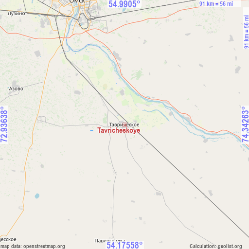
Tavricheskoye GPS coordinates[2]
54° 35' 6.288" North, 73° 38' 22.2" East
| Map corner | latitude | longitude |
|---|---|---|
| Upper-left | 54.9905°, | 72.93638° |
| Center: | 54.58508°, | 73.6395° |
| Lower-right: | 54.17558°, | 74.34263° |
| Map W x H: | 90.6×90.6 km | = 56.3×56.3mi |
| max Lat: | 73.50819° ⇑50.4% North |
| Tavricheskoye: | 54.58508° |
| min Lat: | ⇓49.6% South 41.28413° |
| min Long | Tavricheskoye | max Long |
| -179.12198° | 73.6395° | 179.35046° |
| W 78%⇐ | ⇒22% E |
Elevation
Elevation of Tavricheskoye is 93 m = 305 ft, and this is 109.6 m = 360 ft below average elevation for this country.
| Max E: |
2518 m = 8261 ft | 73.4% |
| Avg. | 202.6 m = 665 ft | |
| Tavricheskoye | 93 m = 305 ft | |
Min E: |
-28 m = -92 ft | 26.6% |
See also: Russia elevation on elevation.city.
Geographical zone
Tavricheskoye is located in North temperate zone (between Tropic of Cancer and the Arctic Circle). Distance of this North polar circle is 1331.9 km =827.6 mi to North.| Distance of | km | miles | from Tavricheskoye |
|---|---|---|---|
| North Pole | 3937.8 | 2446.8 | to North |
| Arctic Circle | 1331.9 | 827.6 | to North |
| Tropic Cancer | 3463.4 | 2152.1 | to South |
| Equator | 6069.3 | 3771.3 | to South |


Nearby cities:
15 places around Tavricheskoye: (largest is in red/bold)
• Azovo
41.6 km =25.8 mi,  287°
287°
• Beregovoy
70.7 km =43.9 mi,  337°
337°
• Irtyshskiy
25.7 km =16 mi,  352°
352°
• Kalachinsk
79.4 km =49.3 mi,  49°
49°
• Kormilovka
55.1 km =34.2 mi,  32°
32°
• Krasnyy Yar
86.1 km =53.5 mi,  328°
328°
• Luzino
56 km =34.8 mi,  316°
316°
• Lyubinskiy
87.6 km =54.4 mi, 316°
• Novoomskiy
35.8 km =22.2 mi, 322°
• Novovarshavka
82.3 km =51.1 mi,  123°
123°
• Odesskoye
60 km =37.3 mi,  226°
226°
• Omsk
48.5 km =30.1 mi, 339°
• Pavlogradka
42.9 km =26.7 mi,  186°
186°
• Sherbakul’
80.2 km =49.8 mi,  273°
273°
• Vkhodnoy
50.7 km =31.5 mi, 323°
Sources, notices
• [Note1] Compared only with cities in Russia existing in our database
• [Src1] Map data: © OpenStreetMap contributors (CC-BY-SA)
• [Src2] Other city data from geonames.org with taken over terms of usage.
• [Src3] Geographical zone / Annual Mean Temperature by Robert A. Rohde @ Wikipedia
