Nyagan geodata
Nyagan (Khanty-Mansia) is a populated place; located in Russia in Asia/Yekaterinburg (GMT+5) time zone. With population of 52,137 people, there are 402 cities with bigger population in this country. Compared to other cities in Russia, 95.1% of cities are located further ↓South; 76% of cities are located further ←West and 86.7% of cities have higher elevation than Nyagan. Note1


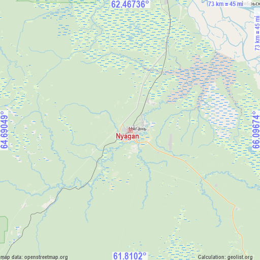
Nyagan GPS coordinates[2]
62° 8' 26.016" North, 65° 23' 36.996" East
| Map corner | latitude | longitude |
|---|---|---|
| Upper-left | 62.46736°, | 64.69049° |
| Center: | 62.14056°, | 65.39361° |
| Lower-right: | 61.8102°, | 66.09674° |
| Map W x H: | 73.1×73.1 km | = 45.4×45.4mi |
| max Lat: | 73.50819° ⇑4.9% North |
| Nyagan: | 62.14056° |
| min Lat: | ⇓95.1% South 41.28413° |
| min Long | Nyagan | max Long |
| -179.12198° | 65.39361° | 179.35046° |
| W 76%⇐ | ⇒24% E |
Elevation
Elevation of Nyagan is 41 m = 135 ft, and this is 161.6 m = 530 ft below average elevation for this country.
| Max E: |
2518 m = 8261 ft | 86.7% |
| Avg. | 202.6 m = 665 ft | |
| Nyagan | 41 m = 135 ft | |
Min E: |
-28 m = -92 ft | 13.3% |
See also: Nyagan elevation on elevation.city.
Geographical zone
Nyagan is located in North temperate zone (between Tropic of Cancer and the Arctic Circle). Distance of this North polar circle is 491.8 km =305.6 mi to North.| Distance of | km | miles | from Nyagan |
|---|---|---|---|
| North Pole | 3097.7 | 1924.8 | to North |
| Arctic Circle | 491.8 | 305.6 | to North |
| Tropic Cancer | 4303.5 | 2674.1 | to South |
| Equator | 6909.4 | 4293.3 | to South |


Nearby cities:
15 places around Nyagan: (largest is in red/bold)
• Agirish
125.9 km =78.2 mi,  259°
259°
• Andra
48.8 km =30.3 mi,  31°
31°
• Beloyarskiy
186.3 km =115.8 mi,  20°
20°
• Berëzovo
200.6 km =124.6 mi,  354°
354°
• Igrim
127 km =78.9 mi,  336°
336°
• Khulimsunt
208.6 km =129.6 mi,  292°
292°
• Kommunisticheskiy
70.1 km =43.6 mi,  222°
222°
• Malinovskiy
170.9 km =106.2 mi,  232°
232°
• Pelym
219.2 km =136.2 mi,  235°
235°
• Pionerskiy
169.7 km =105.4 mi, 231°
• Priob’ye
43.5 km =27 mi,  13°
13°
• Sherkaly
68.8 km =42.8 mi,  3°
3°
• Sovetskiy
128.7 km =80 mi, 227°
• Yugorsk
142.4 km =88.5 mi, 229°
• Zelenoborsk
102.8 km =63.9 mi, 223°
Sources, notices
• [Note1] Compared only with cities in Russia existing in our database
• [Src1] Map data: © OpenStreetMap contributors (CC-BY-SA)
• [Src2] Other city data from geonames.org with taken over terms of usage.
• [Src3] Geographical zone / Annual Mean Temperature by Robert A. Rohde @ Wikipedia
