Tashtagol geodata
Tashtagol (Kemerovo Oblast) is a populated place; located in Russia in Asia/Novokuznetsk (GMT+7) time zone. With population of 22,779 people, there are 796 cities with bigger population in this country. Compared to other cities in Russia, 64.4% of cities are located further ↑North; 85.1% of cities are located further ←West and 91.1% of cities have lower elevation than Tashtagol. Note1


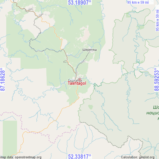
Tashtagol GPS coordinates[2]
52° 45' 56.52" North, 87° 53' 21.84" East
| Map corner | latitude | longitude |
|---|---|---|
| Upper-left | 53.18907°, | 87.18628° |
| Center: | 52.7657°, | 87.8894° |
| Lower-right: | 52.33817°, | 88.59253° |
| Map W x H: | 94.6×94.6 km | = 58.8×58.8mi |
| max Lat: | 73.50819° ⇑64.4% North |
| Tashtagol: | 52.7657° |
| min Lat: | ⇓35.6% South 41.28413° |
| min Long | Tashtagol | max Long |
| -179.12198° | 87.8894° | 179.35046° |
| W 85.1%⇐ | ⇒14.9% E |
Elevation
Elevation of Tashtagol is 478 m = 1568 ft, and this is 275.4 m = 904 ft above average elevation for this country.
| Max E: |
2518 m = 8261 ft | 8.9% |
| Tashtagol | 478 m 1568 ft | |
| Avg. | 202.6 m = 665 ft | |
Min E: |
-28 m = -92 ft | 91.1% |
See also: Russia elevation on elevation.city.
Geographical zone
Tashtagol is located in North temperate zone (between Tropic of Cancer and the Arctic Circle). Distance of this North polar circle is 1534.2 km =953.3 mi to North.| Distance of | km | miles | from Tashtagol |
|---|---|---|---|
| North Pole | 4140.1 | 2572.5 | to North |
| Arctic Circle | 1534.2 | 953.3 | to North |
| Tropic Cancer | 3261.1 | 2026.4 | to South |
| Equator | 5867 | 3645.6 | to South |


Nearby cities:
15 places around Tashtagol: (largest is in red/bold)
• Biyka
94.8 km =58.9 mi,  189°
189°
• Chugunash
14 km =8.7 mi,  329°
329°
• Dmitriyevka
75.1 km =46.7 mi,  241°
241°
• Kaltan
95.7 km =59.5 mi, 333°
• Kaz
42.1 km =26.2 mi,  292°
292°
• Kuzedeyevo
77.8 km =48.3 mi,  323°
323°
• Mezhdurechensk
103.9 km =64.6 mi,  6°
6°
• Mundybash
63.4 km =39.4 mi, 321°
• Osinniki
101.7 km =63.2 mi,  339°
339°
• Sheregesh
18.5 km =11.5 mi,  20°
20°
• Solton
95.2 km =59.2 mi,  275°
275°
• Spassk
9.3 km =5.8 mi,  257°
257°
• Tayzhina
104.8 km =65.1 mi, 343°
• Temirtau
50.6 km =31.4 mi, 324°
• Turochak
76.7 km =47.7 mi,  222°
222°
Sources, notices
• [Note1] Compared only with cities in Russia existing in our database
• [Src1] Map data: © OpenStreetMap contributors (CC-BY-SA)
• [Src2] Other city data from geonames.org with taken over terms of usage.
• [Src3] Geographical zone / Annual Mean Temperature by Robert A. Rohde @ Wikipedia
