Azovo geodata
Azovo (Omsk) is a populated place; located in Russia in Asia/Omsk (GMT+6) time zone. With population of 5,311 people, there are 2504 cities with bigger population in this country. Compared to other cities in Russia, 50.4% of cities are located further ↓South; 77.6% of cities are located further ←West and 67.7% of cities have higher elevation than Azovo. Note1


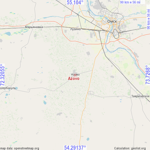
Azovo GPS coordinates[2]
54° 41' 58.992" North, 73° 1' 25.212" East
| Map corner | latitude | longitude |
|---|---|---|
| Upper-left | 55.104°, | 72.32055° |
| Center: | 54.69972°, | 73.02367° |
| Lower-right: | 54.29137°, | 73.7268° |
| Map W x H: | 90.4×90.4 km | = 56.2×56.2mi |
| max Lat: | 73.50819° ⇑49.6% North |
| Azovo: | 54.69972° |
| min Lat: | ⇓50.4% South 41.28413° |
| min Long | Azovo | max Long |
| -179.12198° | 73.02367° | 179.35046° |
| W 77.6%⇐ | ⇒22.4% E |
Elevation
Elevation of Azovo is 108 m = 354 ft, and this is 94.6 m = 310 ft below average elevation for this country.
| Max E: |
2518 m = 8261 ft | 67.7% |
| Avg. | 202.6 m = 665 ft | |
| Azovo | 108 m = 354 ft | |
Min E: |
-28 m = -92 ft | 32.3% |
See also: Russia elevation on elevation.city.
Geographical zone
Azovo is located in North temperate zone (between Tropic of Cancer and the Arctic Circle). Distance of this North polar circle is 1319.1 km =819.7 mi to North.| Distance of | km | miles | from Azovo |
|---|---|---|---|
| North Pole | 3925 | 2438.9 | to North |
| Arctic Circle | 1319.1 | 819.7 | to North |
| Tropic Cancer | 3476.1 | 2159.9 | to South |
| Equator | 6082 | 3779.2 | to South |


Nearby cities:
15 places around Azovo: (largest is in red/bold)
• Beregovoy
54.1 km =33.6 mi,  13°
13°
• Irtyshskiy
38.3 km =23.8 mi,  70°
70°
• Kormilovka
76.9 km =47.8 mi,  64°
64°
• Krasnoyarka
70.7 km =43.9 mi,  4°
4°
• Krasnyy Yar
60.7 km =37.7 mi,  354°
354°
• Krutaya Gorka
75 km =46.6 mi, 9°
• Luzino
27.6 km =17.1 mi, 1°
• Lyubinskiy
54.8 km =34.1 mi,  337°
337°
• Novoomskiy
23.8 km =14.8 mi,  48°
48°
• Odesskoye
54 km =33.6 mi,  184°
184°
• Omsk
39.3 km =24.4 mi,  34°
34°
• Pavlogradka
65.2 km =40.5 mi,  147°
147°
• Sherbakul’
41 km =25.5 mi,  259°
259°
• Tavricheskoye
41.6 km =25.8 mi,  107°
107°
• Vkhodnoy
29.6 km =18.4 mi,  18°
18°
Sources, notices
• [Note1] Compared only with cities in Russia existing in our database
• [Src1] Map data: © OpenStreetMap contributors (CC-BY-SA)
• [Src2] Other city data from geonames.org with taken over terms of usage.
• [Src3] Geographical zone / Annual Mean Temperature by Robert A. Rohde @ Wikipedia
