Kolosovka geodata
Kolosovka (Omsk) is a populated place; located in Russia in Asia/Omsk (GMT+6) time zone. With population of 5,759 people, there are 2344 cities with bigger population in this country. Compared to other cities in Russia, 72.3% of cities are located further ↓South; 77.9% of cities are located further ←West and 73.4% of cities have higher elevation than Kolosovka. Note1


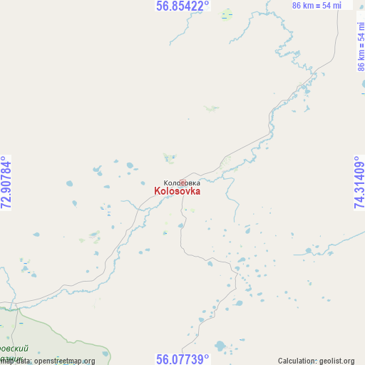
Kolosovka GPS coordinates[2]
56° 28' 4.044" North, 73° 36' 39.456" East
| Map corner | latitude | longitude |
|---|---|---|
| Upper-left | 56.85422°, | 72.90784° |
| Center: | 56.46779°, | 73.61096° |
| Lower-right: | 56.07739°, | 74.31409° |
| Map W x H: | 86.4×86.4 km | = 53.7×53.7mi |
| max Lat: | 73.50819° ⇑27.7% North |
| Kolosovka: | 56.46779° |
| min Lat: | ⇓72.3% South 41.28413° |
| min Long | Kolosovka | max Long |
| -179.12198° | 73.61096° | 179.35046° |
| W 77.9%⇐ | ⇒22.1% E |
Elevation
Elevation of Kolosovka is 93 m = 305 ft, and this is 109.6 m = 360 ft below average elevation for this country.
| Max E: |
2518 m = 8261 ft | 73.4% |
| Avg. | 202.6 m = 665 ft | |
| Kolosovka | 93 m = 305 ft | |
Min E: |
-28 m = -92 ft | 26.6% |
See also: Russia elevation on elevation.city.
Geographical zone
Kolosovka is located in North temperate zone (between Tropic of Cancer and the Arctic Circle). Distance of this North polar circle is 1122.5 km =697.5 mi to North.| Distance of | km | miles | from Kolosovka |
|---|---|---|---|
| North Pole | 3728.4 | 2316.7 | to North |
| Arctic Circle | 1122.5 | 697.5 | to North |
| Tropic Cancer | 3672.7 | 2282.1 | to South |
| Equator | 6278.6 | 3901.3 | to South |


Nearby cities:
15 places around Kolosovka: (largest is in red/bold)
• Beregovoy
146 km =90.7 mi,  189°
189°
• Bol’sherech’ye
75.3 km =46.8 mi,  123°
123°
• Krasnoyarka
129.8 km =80.7 mi, 193°
• Krasnyy Yar
142.8 km =88.7 mi,  197°
197°
• Krutaya Gorka
125 km =77.7 mi, 191°
• Krutinka
139.6 km =86.7 mi,  248°
248°
• Lyubinskiy
156.9 km =97.5 mi, 201°
• Muromtsevo
100.8 km =62.6 mi,  96°
96°
• Nizhnyaya Omka
141.7 km =88 mi,  144°
144°
• Sargatskoye
95.6 km =59.4 mi,  184°
184°
• Tara
66.4 km =41.3 mi,  44°
44°
• Tevriz
136.9 km =85.1 mi,  327°
327°
• Troitsk
120.7 km =75 mi,  225°
225°
• Tyukalinsk
109.7 km =68.2 mi, 232°
• Znamenskoye
74.6 km =46.4 mi,  10°
10°
Sources, notices
• [Note1] Compared only with cities in Russia existing in our database
• [Src1] Map data: © OpenStreetMap contributors (CC-BY-SA)
• [Src2] Other city data from geonames.org with taken over terms of usage.
• [Src3] Geographical zone / Annual Mean Temperature by Robert A. Rohde @ Wikipedia
