Muromtsevo geodata
Muromtsevo (Omsk) is a populated place; located in Russia in Asia/Omsk (GMT+6) time zone. With population of 11,147 people, there are 1356 cities with bigger population in this country. Compared to other cities in Russia, 71.3% of cities are located further ↓South; 78.3% of cities are located further ←West and 78.7% of cities have higher elevation than Muromtsevo. Note1


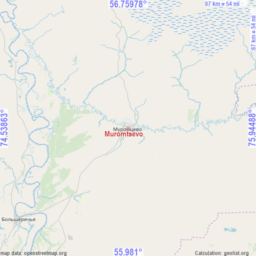
Muromtsevo GPS coordinates[2]
56° 22' 20.568" North, 75° 14' 30.3" East
| Map corner | latitude | longitude |
|---|---|---|
| Upper-left | 56.75978°, | 74.53863° |
| Center: | 56.37238°, | 75.24175° |
| Lower-right: | 55.981°, | 75.94488° |
| Map W x H: | 86.6×86.6 km | = 53.8×53.8mi |
| max Lat: | 73.50819° ⇑28.7% North |
| Muromtsevo: | 56.37238° |
| min Lat: | ⇓71.3% South 41.28413° |
| min Long | Muromtsevo | max Long |
| -179.12198° | 75.24175° | 179.35046° |
| W 78.3%⇐ | ⇒21.7% E |
Elevation
Elevation of Muromtsevo is 75 m = 246 ft, and this is 127.6 m = 419 ft below average elevation for this country.
| Max E: |
2518 m = 8261 ft | 78.7% |
| Avg. | 202.6 m = 665 ft | |
| Muromtsevo | 75 m = 246 ft | |
Min E: |
-28 m = -92 ft | 21.3% |
See also: Russia elevation on elevation.city.
Geographical zone
Muromtsevo is located in North temperate zone (between Tropic of Cancer and the Arctic Circle). Distance of this North polar circle is 1133.2 km =704.1 mi to North.| Distance of | km | miles | from Muromtsevo |
|---|---|---|---|
| North Pole | 3739 | 2323.3 | to North |
| Arctic Circle | 1133.2 | 704.1 | to North |
| Tropic Cancer | 3662.1 | 2275.5 | to South |
| Equator | 6268 | 3894.8 | to South |


Nearby cities:
15 places around Muromtsevo: (largest is in red/bold)
• Bol’sherech’ye
49.1 km =30.5 mi,  230°
230°
• Chany
151.5 km =94.1 mi,  141°
141°
• Kalachinsk
152.5 km =94.8 mi,  195°
195°
• Kolosovka
100.8 km =62.6 mi,  276°
276°
• Kormilovka
168.2 km =104.5 mi,  205°
205°
• Krutaya Gorka
168.5 km =104.7 mi, 228°
• Kyshtovka
87.5 km =54.4 mi,  76°
76°
• Nizhnyaya Omka
106 km =65.9 mi,  190°
190°
• Okoneshnikovo
170.9 km =106.2 mi,  183°
183°
• Sargatskoye
137.7 km =85.6 mi, 232°
• Tara
78.8 km =49 mi,  317°
317°
• Tatarsk
136.3 km =84.7 mi,  160°
160°
• Ust’-Tarka
94.1 km =58.5 mi, 162°
• Vengerovo
120.8 km =75.1 mi,  129°
129°
• Znamenskoye
120.4 km =74.8 mi,  314°
314°
Sources, notices
• [Note1] Compared only with cities in Russia existing in our database
• [Src1] Map data: © OpenStreetMap contributors (CC-BY-SA)
• [Src2] Other city data from geonames.org with taken over terms of usage.
• [Src3] Geographical zone / Annual Mean Temperature by Robert A. Rohde @ Wikipedia
