Kazanskoye geodata
Kazanskoye (Tyumen’ Oblast) is a populated place; located in Russia in Asia/Yekaterinburg (GMT+5) time zone. With population of 5,851 people, there are 2314 cities with bigger population in this country. Compared to other cities in Russia, 60.6% of cities are located further ↓South; 77% of cities are located further ←West and 75.8% of cities have higher elevation than Kazanskoye. Note1


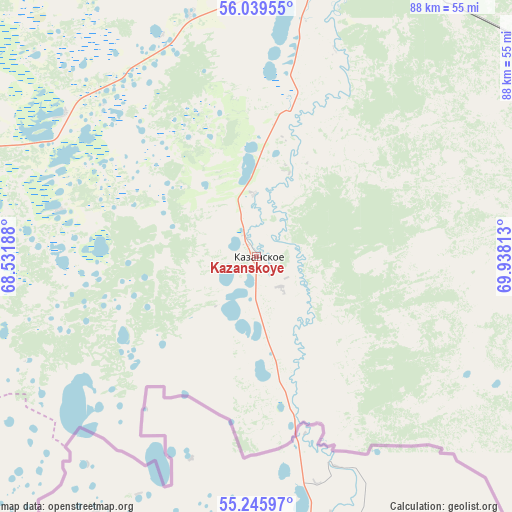
Kazanskoye GPS coordinates[2]
55° 38' 41.172" North, 69° 14' 6" East
| Map corner | latitude | longitude |
|---|---|---|
| Upper-left | 56.03955°, | 68.53188° |
| Center: | 55.64477°, | 69.235° |
| Lower-right: | 55.24597°, | 69.93813° |
| Map W x H: | 88.2×88.2 km | = 54.8×54.8mi |
| max Lat: | 73.50819° ⇑39.4% North |
| Kazanskoye: | 55.64477° |
| min Lat: | ⇓60.6% South 41.28413° |
| min Long | Kazanskoye | max Long |
| -179.12198° | 69.235° | 179.35046° |
| W 77%⇐ | ⇒23% E |
Elevation
Elevation of Kazanskoye is 85 m = 279 ft, and this is 117.6 m = 386 ft below average elevation for this country.
| Max E: |
2518 m = 8261 ft | 75.8% |
| Avg. | 202.6 m = 665 ft | |
| Kazanskoye | 85 m = 279 ft | |
Min E: |
-28 m = -92 ft | 24.2% |
See also: Russia elevation on elevation.city.
Geographical zone
Kazanskoye is located in North temperate zone (between Tropic of Cancer and the Arctic Circle). Distance of this North polar circle is 1214.1 km =754.4 mi to North.| Distance of | km | miles | from Kazanskoye |
|---|---|---|---|
| North Pole | 3819.9 | 2373.6 | to North |
| Arctic Circle | 1214.1 | 754.4 | to North |
| Tropic Cancer | 3581.2 | 2225.3 | to South |
| Equator | 6187.1 | 3844.5 | to South |


Nearby cities:
15 places around Kazanskoye: (largest is in red/bold)
• Abatskoye
104.3 km =64.8 mi,  46°
46°
• Armizonskoye
103.2 km =64.1 mi,  288°
288°
• Aromashevo
140.1 km =87.1 mi,  344°
344°
• Golyshmanovo
99.4 km =61.8 mi,  327°
327°
• Ishim
54.4 km =33.8 mi,  17°
17°
• Krutinka
147.7 km =91.8 mi,  74°
74°
• Makushino
134.6 km =83.6 mi,  248°
248°
• Mokrousovo
155.7 km =96.7 mi,  276°
276°
• Nazyvayevsk
133.3 km =82.8 mi,  93°
93°
• Novoseleznëvo
4.5 km =2.8 mi, 336°
• Omutinskiy
133.9 km =83.2 mi,  313°
313°
• Petukhovo
105.8 km =65.7 mi,  232°
232°
• Sladkovo
70.5 km =43.8 mi,  100°
100°
• Uspenka
128.6 km =79.9 mi,  359°
359°
• Vikulovo
155.6 km =96.7 mi,  33°
33°
Sources, notices
• [Note1] Compared only with cities in Russia existing in our database
• [Src1] Map data: © OpenStreetMap contributors (CC-BY-SA)
• [Src2] Other city data from geonames.org with taken over terms of usage.
• [Src3] Geographical zone / Annual Mean Temperature by Robert A. Rohde @ Wikipedia
