Karasuk geodata
Karasuk (Novosibirsk Oblast) is a populated place; located in Russia in Asia/Novosibirsk (GMT+7) time zone. With population of 28,589 people, there are 684 cities with bigger population in this country. Compared to other cities in Russia, 57.1% of cities are located further ↑North; 78.7% of cities are located further ←West and 65% of cities have higher elevation than Karasuk. Note1


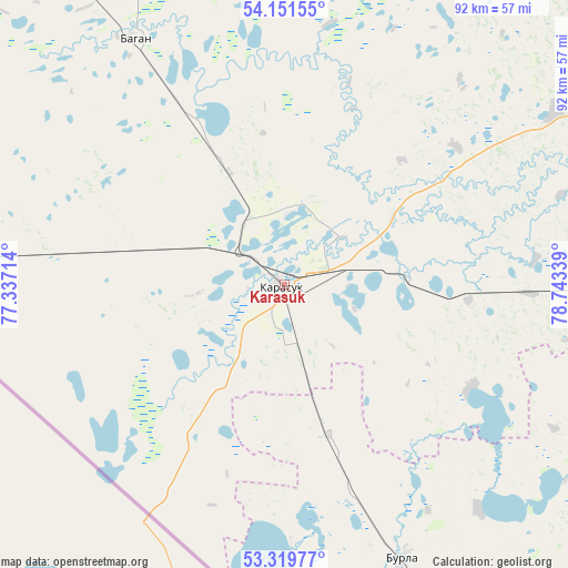
Karasuk GPS coordinates[2]
53° 44' 15.792" North, 78° 2' 24.936" East
| Map corner | latitude | longitude |
|---|---|---|
| Upper-left | 54.15155°, | 77.33714° |
| Center: | 53.73772°, | 78.04026° |
| Lower-right: | 53.31977°, | 78.74339° |
| Map W x H: | 92.5×92.5 km | = 57.5×57.5mi |
| max Lat: | 73.50819° ⇑57.1% North |
| Karasuk: | 53.73772° |
| min Lat: | ⇓42.9% South 41.28413° |
| min Long | Karasuk | max Long |
| -179.12198° | 78.04026° | 179.35046° |
| W 78.7%⇐ | ⇒21.3% E |
Elevation
Elevation of Karasuk is 114 m = 374 ft, and this is 88.6 m = 291 ft below average elevation for this country.
| Max E: |
2518 m = 8261 ft | 65% |
| Avg. | 202.6 m = 665 ft | |
| Karasuk | 114 m = 374 ft | |
Min E: |
-28 m = -92 ft | 35% |
See also: Russia elevation on elevation.city.
Geographical zone
Karasuk is located in North temperate zone (between Tropic of Cancer and the Arctic Circle). Distance of this North polar circle is 1426.1 km =886.1 mi to North.| Distance of | km | miles | from Karasuk |
|---|---|---|---|
| North Pole | 4032 | 2505.4 | to North |
| Arctic Circle | 1426.1 | 886.1 | to North |
| Tropic Cancer | 3369.2 | 2093.5 | to South |
| Equator | 5975.1 | 3712.8 | to South |


Nearby cities:
15 places around Karasuk: (largest is in red/bold)
• Bagan
47.2 km =29.3 mi,  328°
328°
• Burla
48.6 km =30.2 mi,  156°
156°
• Bursol’
68.7 km =42.7 mi, 157°
• Gal’bshtadt
84.5 km =52.5 mi,  132°
132°
• Grishkovka
80.7 km =50.1 mi,  144°
144°
• Krasnozërskoye
83.1 km =51.6 mi,  70°
70°
• Kupino
85 km =52.8 mi, 325°
• Kusak
82.2 km =51.1 mi, 134°
• Novopeschanoye
48.4 km =30.1 mi, 138°
• Podsosnovo
70.8 km =44 mi, 125°
• Polovinnoye
79.1 km =49.2 mi,  88°
88°
• Slavgorod
91.5 km =56.9 mi,  154°
154°
• Slavgorodskoye
89.1 km =55.4 mi, 153°
• Ust’yanka
56.1 km =34.9 mi,  124°
124°
• Yarovoye
97 km =60.3 mi, 158°
Sources, notices
• [Note1] Compared only with cities in Russia existing in our database
• [Src1] Map data: © OpenStreetMap contributors (CC-BY-SA)
• [Src2] Other city data from geonames.org with taken over terms of usage.
• [Src3] Geographical zone / Annual Mean Temperature by Robert A. Rohde @ Wikipedia
