Ust’yanka geodata
Ust’yanka (Altai Krai) is a populated place; located in Russia in Asia/Barnaul (GMT+7) time zone. With population of 1,086 people, there are 4592 cities with bigger population in this country. Compared to other cities in Russia, 59.1% of cities are located further ↑North; 79% of cities are located further ←West and 63% of cities have higher elevation than Ust’yanka. Note1


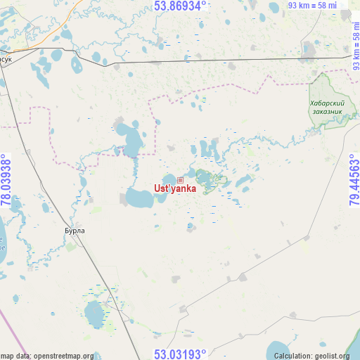
Ust’yanka GPS coordinates[2]
53° 27' 9.72" North, 78° 44' 33" East
| Map corner | latitude | longitude |
|---|---|---|
| Upper-left | 53.86934°, | 78.03938° |
| Center: | 53.4527°, | 78.7425° |
| Lower-right: | 53.03193°, | 79.44563° |
| Map W x H: | 93.1×93.1 km | = 57.8×57.8mi |
| max Lat: | 73.50819° ⇑59.1% North |
| Ust’yanka: | 53.4527° |
| min Lat: | ⇓40.9% South 41.28413° |
| min Long | Ust’yanka | max Long |
| -179.12198° | 78.7425° | 179.35046° |
| W 79%⇐ | ⇒21% E |
Elevation
Elevation of Ust’yanka is 118 m = 387 ft, and this is 84.6 m = 278 ft below average elevation for this country.
| Max E: |
2518 m = 8261 ft | 63% |
| Avg. | 202.6 m = 665 ft | |
| Ust’yanka | 118 m = 387 ft | |
Min E: |
-28 m = -92 ft | 37% |
See also: Russia elevation on elevation.city.
Geographical zone
Ust’yanka is located in North temperate zone (between Tropic of Cancer and the Arctic Circle). Distance of this North polar circle is 1457.8 km =905.8 mi to North.| Distance of | km | miles | from Ust’yanka |
|---|---|---|---|
| North Pole | 4063.7 | 2525.1 | to North |
| Arctic Circle | 1457.8 | 905.8 | to North |
| Tropic Cancer | 3337.5 | 2073.8 | to South |
| Equator | 5943.4 | 3693.1 | to South |


Nearby cities:
15 places around Ust’yanka: (largest is in red/bold)
• Burla
30.3 km =18.8 mi,  244°
244°
• Bursol’
37.4 km =23.2 mi,  212°
212°
• Gal’bshtadt
29.9 km =18.6 mi,  147°
147°
• Grishkovka
33.8 km =21 mi,  179°
179°
• Karasuk
56.1 km =34.9 mi,  304°
304°
• Khabary
55.8 km =34.7 mi,  69°
69°
• Krasnozërskoye
67.3 km =41.8 mi,  28°
28°
• Kusak
28.4 km =17.6 mi, 153°
• Novopeschanoye
15.4 km =9.6 mi,  251°
251°
• Podsosnovo
14.7 km =9.1 mi,  127°
127°
• Polovinnoye
47.3 km =29.4 mi,  44°
44°
• Slavgorod
51 km =31.7 mi,  187°
187°
• Slavgorodskoye
48.4 km =30.1 mi, 187°
• Tabuny
75.2 km =46.7 mi, 177°
• Yarovoye
59.4 km =36.9 mi, 190°
Sources, notices
• [Note1] Compared only with cities in Russia existing in our database
• [Src1] Map data: © OpenStreetMap contributors (CC-BY-SA)
• [Src2] Other city data from geonames.org with taken over terms of usage.
• [Src3] Geographical zone / Annual Mean Temperature by Robert A. Rohde @ Wikipedia
