Polovinnoye geodata
Polovinnoye (Novosibirsk Oblast) is a populated place; located in Russia in Asia/Novosibirsk (GMT+7) time zone. With population of 3,530 people, there are 3381 cities with bigger population in this country. Compared to other cities in Russia, 56.9% of cities are located further ↑North; 79.2% of cities are located further ←West and 62.9% of cities have lower elevation than Polovinnoye. Note1


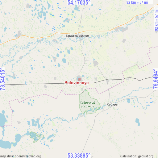
Polovinnoye GPS coordinates[2]
53° 45' 24.156" North, 79° 14' 35.772" East
| Map corner | latitude | longitude |
|---|---|---|
| Upper-left | 54.17035°, | 78.54015° |
| Center: | 53.75671°, | 79.24327° |
| Lower-right: | 53.33895°, | 79.9464° |
| Map W x H: | 92.4×92.4 km | = 57.4×57.4mi |
| max Lat: | 73.50819° ⇑56.9% North |
| Polovinnoye: | 53.75671° |
| min Lat: | ⇓43.1% South 41.28413° |
| min Long | Polovinnoye | max Long |
| -179.12198° | 79.24327° | 179.35046° |
| W 79.2%⇐ | ⇒20.8% E |
Elevation
Elevation of Polovinnoye is 176 m = 577 ft, and this is 26.6 m = 87 ft below average elevation for this country.
| Max E: |
2518 m = 8261 ft | 37.1% |
| Avg. | 202.6 m = 665 ft | |
| Polovinnoye | 176 m = 577 ft | |
Min E: |
-28 m = -92 ft | 62.9% |
See also: Russia elevation on elevation.city.
Geographical zone
Polovinnoye is located in North temperate zone (between Tropic of Cancer and the Arctic Circle). Distance of this North polar circle is 1424 km =884.8 mi to North.| Distance of | km | miles | from Polovinnoye |
|---|---|---|---|
| North Pole | 4029.9 | 2504.1 | to North |
| Arctic Circle | 1424 | 884.8 | to North |
| Tropic Cancer | 3371.3 | 2094.8 | to South |
| Equator | 5977.2 | 3714.1 | to South |


Nearby cities:
15 places around Polovinnoye: (largest is in red/bold)
• Burla
76.3 km =47.4 mi,  232°
232°
• Bursol’
84.2 km =52.3 mi,  218°
218°
• Gal’bshtadt
61.4 km =38.2 mi,  196°
196°
• Grishkovka
75.1 km =46.7 mi,  205°
205°
• Karasuk
79.1 km =49.2 mi,  268°
268°
• Khabary
24.1 km =15 mi,  127°
127°
• Krasnozërskoye
25.1 km =15.6 mi,  359°
359°
• Kusak
62.7 km =39 mi, 199°
• Novopeschanoye
61.4 km =38.2 mi, 230°
• Pankrushikha
72.6 km =45.1 mi,  83°
83°
• Podsosnovo
47.8 km =29.7 mi, 206°
• Slavgorod
93.3 km =58 mi, 205°
• Slavgorodskoye
90.9 km =56.5 mi, 205°
• Ust’yanka
47.3 km =29.4 mi, 224°
• Verkh-Suetka
73.2 km =45.5 mi, 133°
Sources, notices
• [Note1] Compared only with cities in Russia existing in our database
• [Src1] Map data: © OpenStreetMap contributors (CC-BY-SA)
• [Src2] Other city data from geonames.org with taken over terms of usage.
• [Src3] Geographical zone / Annual Mean Temperature by Robert A. Rohde @ Wikipedia
