Burla geodata
Burla (Altai Krai) is a populated place; located in Russia in Asia/Barnaul (GMT+7) time zone. With population of 4,682 people, there are 2791 cities with bigger population in this country. Compared to other cities in Russia, 60% of cities are located further ↑North; 78.8% of cities are located further ←West and 66% of cities have higher elevation than Burla. Note1


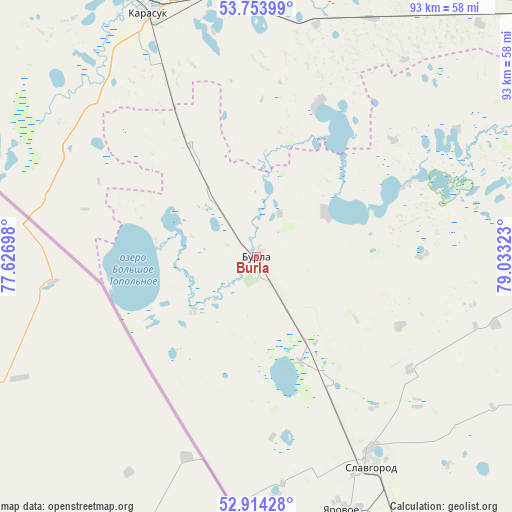
Burla GPS coordinates[2]
53° 20' 10.32" North, 78° 19' 48.36" East
| Map corner | latitude | longitude |
|---|---|---|
| Upper-left | 53.75399°, | 77.62698° |
| Center: | 53.3362°, | 78.3301° |
| Lower-right: | 52.91428°, | 79.03323° |
| Map W x H: | 93.4×93.4 km | = 58×58mi |
| max Lat: | 73.50819° ⇑60% North |
| Burla: | 53.3362° |
| min Lat: | ⇓40% South 41.28413° |
| min Long | Burla | max Long |
| -179.12198° | 78.3301° | 179.35046° |
| W 78.8%⇐ | ⇒21.2% E |
Elevation
Elevation of Burla is 111 m = 364 ft, and this is 91.6 m = 301 ft below average elevation for this country.
| Max E: |
2518 m = 8261 ft | 66% |
| Avg. | 202.6 m = 665 ft | |
| Burla | 111 m = 364 ft | |
Min E: |
-28 m = -92 ft | 34% |
See also: Russia elevation on elevation.city.
Geographical zone
Burla is located in North temperate zone (between Tropic of Cancer and the Arctic Circle). Distance of this North polar circle is 1470.7 km =913.9 mi to North.| Distance of | km | miles | from Burla |
|---|---|---|---|
| North Pole | 4076.6 | 2533.1 | to North |
| Arctic Circle | 1470.7 | 913.9 | to North |
| Tropic Cancer | 3324.5 | 2065.7 | to South |
| Equator | 5930.4 | 3685 | to South |


Nearby cities:
15 places around Burla: (largest is in red/bold)
• Bursol’
20.1 km =12.5 mi,  158°
158°
• Gal’bshtadt
45.2 km =28.1 mi,  105°
105°
• Grishkovka
34.9 km =21.7 mi,  126°
126°
• Karasuk
48.6 km =30.2 mi,  336°
336°
• Khabary
86 km =53.4 mi,  67°
67°
• Krasnozërskoye
93.5 km =58.1 mi,  39°
39°
• Kusak
42 km =26.1 mi, 107°
• Novopeschanoye
15.1 km =9.4 mi,  57°
57°
• Podsosnovo
39.2 km =24.4 mi,  84°
84°
• Polovinnoye
76.3 km =47.4 mi,  52°
52°
• Slavgorod
43.1 km =26.8 mi,  150°
150°
• Slavgorodskoye
40.8 km =25.4 mi, 149°
• Tabuny
69.3 km =43.1 mi, 153°
• Ust’yanka
30.3 km =18.8 mi, 64°
• Yarovoye
48.4 km =30.1 mi, 159°
Sources, notices
• [Note1] Compared only with cities in Russia existing in our database
• [Src1] Map data: © OpenStreetMap contributors (CC-BY-SA)
• [Src2] Other city data from geonames.org with taken over terms of usage.
• [Src3] Geographical zone / Annual Mean Temperature by Robert A. Rohde @ Wikipedia
