Toguchin geodata
Toguchin (Novosibirsk Oblast) is a populated place; located in Russia in Asia/Novosibirsk (GMT+7) time zone. With population of 21,886 people, there are 820 cities with bigger population in this country. Compared to other cities in Russia, 55.6% of cities are located further ↓South; 81.7% of cities are located further ←West and 51.9% of cities have lower elevation than Toguchin. Note1


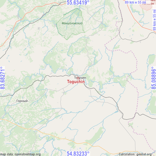
Toguchin GPS coordinates[2]
55° 14' 7.008" North, 84° 23' 8.988" East
| Map corner | latitude | longitude |
|---|---|---|
| Upper-left | 55.63419°, | 83.68271° |
| Center: | 55.23528°, | 84.38583° |
| Lower-right: | 54.83233°, | 85.08896° |
| Map W x H: | 89.2×89.2 km | = 55.4×55.4mi |
| max Lat: | 73.50819° ⇑44.4% North |
| Toguchin: | 55.23528° |
| min Lat: | ⇓55.6% South 41.28413° |
| min Long | Toguchin | max Long |
| -179.12198° | 84.38583° | 179.35046° |
| W 81.7%⇐ | ⇒18.3% E |
Elevation
Elevation of Toguchin is 149 m = 489 ft, and this is 53.6 m = 176 ft below average elevation for this country.
| Max E: |
2518 m = 8261 ft | 48.1% |
| Avg. | 202.6 m = 665 ft | |
| Toguchin | 149 m = 489 ft | |
Min E: |
-28 m = -92 ft | 51.9% |
See also: Russia elevation on elevation.city.
Geographical zone
Toguchin is located in North temperate zone (between Tropic of Cancer and the Arctic Circle). Distance of this North polar circle is 1259.6 km =782.7 mi to North.| Distance of | km | miles | from Toguchin |
|---|---|---|---|
| North Pole | 3865.5 | 2401.9 | to North |
| Arctic Circle | 1259.6 | 782.7 | to North |
| Tropic Cancer | 3535.7 | 2197 | to South |
| Equator | 6141.6 | 3816.2 | to South |


Nearby cities:
15 places around Toguchin: (largest is in red/bold)
• Baryshevo
82.6 km =51.3 mi,  247°
247°
• Bazoy
85.7 km =53.3 mi,  311°
311°
• Bolotnoye
48.5 km =30.1 mi,  0°
0°
• Dubrovino
74.1 km =46 mi,  290°
290°
• Gornyy
33.3 km =20.7 mi, 246°
• Kol’tsovo
83.4 km =51.8 mi, 246°
• Mochishche
80.6 km =50.1 mi,  263°
263°
• Moshkovo
49.7 km =30.9 mi,  279°
279°
• Novolugovoye
85.8 km =53.3 mi, 250°
• Sokur
67.7 km =42.1 mi,  267°
267°
• Stantsionno-Oyashinskiy
43.8 km =27.2 mi, 305°
• Tashara
63.8 km =39.6 mi,  299°
299°
• Topki
78.1 km =48.5 mi,  86°
86°
• Yurga
62.7 km =39 mi,  30°
30°
• Zhuravlevo
66.1 km =41.1 mi,  139°
139°
Sources, notices
• [Note1] Compared only with cities in Russia existing in our database
• [Src1] Map data: © OpenStreetMap contributors (CC-BY-SA)
• [Src2] Other city data from geonames.org with taken over terms of usage.
• [Src3] Geographical zone / Annual Mean Temperature by Robert A. Rohde @ Wikipedia
