Unaizah geodata
Unaizah (Al-Qassim) is a seat of a second-order administrative division; located in Saudi Arabia in Asia/Riyadh (GMT+3) time zone. In our database, there are 96 cities with bigger population. Compared to other cities in Saudi Arabia, 64.9% of cities are located further ↓South; 51.5% of cities are located further ←West and 70.1% of cities have lower elevation than Unaizah. Note1


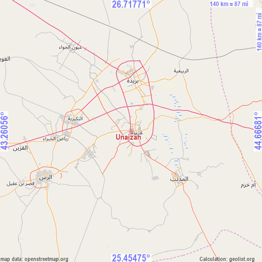
Unaizah GPS coordinates[2]
26° 5' 16.548" North, 43° 57' 49.248" East
| Map corner | latitude | longitude |
|---|---|---|
| Upper-left | 26.71771°, | 43.26056° |
| Center: | 26.08793°, | 43.96368° |
| Lower-right: | 25.45475°, | 44.66681° |
| Map W x H: | 140.4×140.4 km | = 87.2×87.2mi |
| max Lat: | 31.67252° ⇑35.1% North |
| Unaizah: | 26.08793° |
| min Lat: | ⇓64.9% South 16.57946° |
| min Long | Unaizah | max Long |
| 35.69014° | 43.96368° | 54.09599° |
| W 51.5%⇐ | ⇒48.5% E |
Elevation
Elevation of Unaizah is 654 m = 2146 ft, and this is 132.6 m = 435 ft above average elevation for this country.
| Max E: |
2385 m = 7825 ft | 29.9% |
| Unaizah | 654 m 2146 ft | |
| Avg. | 521.4 m = 1711 ft | |
Min E: |
3 m = 10 ft | 70.1% |
See also: Saudi Arabia elevation on elevation.city.
Geographical zone
Unaizah is located in North temperate zone (between Tropic of Cancer and the Arctic Circle). Distance of this Northern Tropic circle is 294.8 km =183.2 mi to South.| Distance of | km | miles | from Unaizah |
|---|---|---|---|
| North Pole | 7106.4 | 4415.7 | to North |
| Arctic Circle | 4500.5 | 2796.5 | to North |
| Tropic Cancer | 294.8 | 183.2 | to South |
| Equator | 2900.7 | 1802.4 | to South |


Nearby cities:
15 places around Unaizah: (largest is in red/bold)
• Ad Dawādimī
180.9 km =112.4 mi,  166°
166°
• Adh Dhibiyah
80.9 km =50.3 mi,  265°
265°
• Ain AlBaraha
149.1 km =92.6 mi,  187°
187°
• Al Arţāwīyah
145.5 km =90.4 mi,  71°
71°
• Al Bukayrīyah
31.1 km =19.3 mi,  280°
280°
• Al Fuwayliq
81.3 km =50.5 mi,  299°
299°
• Al Majma‘ah
140.6 km =87.4 mi,  98°
98°
• Al Mithnab
36.2 km =22.5 mi,  134°
134°
• Alrmtheiah
180.6 km =112.2 mi,  214°
214°
• Ar Rass
52.6 km =32.7 mi,  242°
242°
• Az Zulfī
88.2 km =54.8 mi, 74°
• Buraydah
26.5 km =16.5 mi,  2°
2°
• Sājir
119.2 km =74.1 mi,  147°
147°
• Tanūmah
113.8 km =70.7 mi,  8°
8°
• Wed Alnkil
134.9 km =83.8 mi, 236°
Sources, notices
• [Note1] Compared only with cities in Saudi Arabia existing in our database
• [Src1] Map data: © OpenStreetMap contributors (CC-BY-SA)
• [Src2] Other city data from geonames.org with taken over terms of usage.
• [Src3] Geographical zone / Annual Mean Temperature by Robert A. Rohde @ Wikipedia
