Ar Rass geodata
Ar Rass (Al-Qassim) is a populated place; located in Saudi Arabia in Asia/Riyadh (GMT+3) time zone. With population of 81,728 people, there are 29 cities with bigger population in this country. Compared to other cities in Saudi Arabia, 60.8% of cities are located further ↓South; 51.5% of cities are located further →East and 72.2% of cities have lower elevation than Ar Rass. Note1


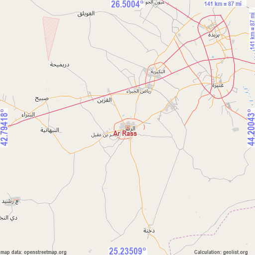
Ar Rass GPS coordinates[2]
25° 52' 9.984" North, 43° 29' 50.28" East
| Map corner | latitude | longitude |
|---|---|---|
| Upper-left | 26.5004°, | 42.79418° |
| Center: | 25.86944°, | 43.4973° |
| Lower-right: | 25.23509°, | 44.20043° |
| Map W x H: | 140.7×140.7 km | = 87.4×87.4mi |
| max Lat: | 31.67252° ⇑39.2% North |
| Ar Rass: | 25.86944° |
| min Lat: | ⇓60.8% South 16.57946° |
| min Long | Ar Rass | max Long |
| 35.69014° | 43.4973° | 54.09599° |
| W 48.5%⇐ | ⇒51.5% E |
Elevation
Elevation of Ar Rass is 691 m = 2267 ft, and this is 169.6 m = 556 ft above average elevation for this country.
| Max E: |
2385 m = 7825 ft | 27.8% |
| Ar Rass | 691 m 2267 ft | |
| Avg. | 521.4 m = 1711 ft | |
Min E: |
3 m = 10 ft | 72.2% |
See also: Ar Rass elevation on elevation.city.
Geographical zone
Ar Rass is located in North temperate zone (between Tropic of Cancer and the Arctic Circle). Distance of this Northern Tropic circle is 270.5 km =168.1 mi to South.| Distance of | km | miles | from Ar Rass |
|---|---|---|---|
| North Pole | 7130.6 | 4430.7 | to North |
| Arctic Circle | 4524.8 | 2811.6 | to North |
| Tropic Cancer | 270.5 | 168.1 | to South |
| Equator | 2876.4 | 1787.3 | to South |


Nearby cities:
15 places around Ar Rass: (largest is in red/bold)
• Ad Dawādimī
176.2 km =109.5 mi,  149°
149°
• Adh Dhibiyah
38.3 km =23.8 mi,  297°
297°
• Ain AlBaraha
126.7 km =78.7 mi,  167°
167°
• Al Arţāwīyah
197.7 km =122.8 mi,  69°
69°
• Al Bukayrīyah
34 km =21.1 mi,  28°
28°
• Al Fuwayliq
68.4 km =42.5 mi,  338°
338°
• Al Majma‘ah
186 km =115.6 mi,  88°
88°
• Al Mithnab
72.5 km =45 mi, 90°
• Alrmtheiah
136.6 km =84.9 mi,  203°
203°
• Az Zulfī
140 km =87 mi, 70°
• Buraydah
69.7 km =43.3 mi,  43°
43°
• Sājir
134.4 km =83.5 mi,  124°
124°
• Tanūmah
150.8 km =93.7 mi,  24°
24°
• Unaizah
52.6 km =32.7 mi,  62°
62°
• Wed Alnkil
82.7 km =51.4 mi,  233°
233°
Sources, notices
• [Note1] Compared only with cities in Saudi Arabia existing in our database
• [Src1] Map data: © OpenStreetMap contributors (CC-BY-SA)
• [Src2] Other city data from geonames.org with taken over terms of usage.
• [Src3] Geographical zone / Annual Mean Temperature by Robert A. Rohde @ Wikipedia
