Buraydah geodata
Buraydah (Al-Qassim) is a seat of a first-order administrative division; located in Saudi Arabia in Asia/Riyadh (GMT+3) time zone. With population of 391,336 people, there are 9 cities with bigger population in this country. Compared to other cities in Saudi Arabia, 71.1% of cities are located further ↓South; 52.6% of cities are located further ←West and 61.9% of cities have lower elevation than Buraydah. Note1


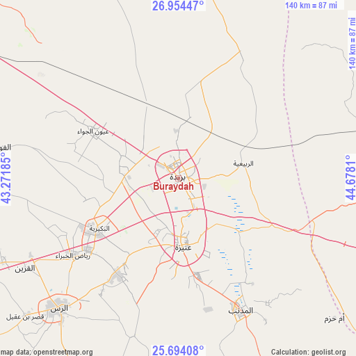
Buraydah GPS coordinates[2]
26° 19' 33.564" North, 43° 58' 29.892" East
| Map corner | latitude | longitude |
|---|---|---|
| Upper-left | 26.95447°, | 43.27185° |
| Center: | 26.32599°, | 43.97497° |
| Lower-right: | 25.69408°, | 44.6781° |
| Map W x H: | 140.1×140.1 km | = 87.1×87.1mi |
| max Lat: | 31.67252° ⇑28.9% North |
| Buraydah: | 26.32599° |
| min Lat: | ⇓71.1% South 16.57946° |
| min Long | Buraydah | max Long |
| 35.69014° | 43.97497° | 54.09599° |
| W 52.6%⇐ | ⇒47.4% E |
Elevation
Elevation of Buraydah is 606 m = 1988 ft, and this is 84.6 m = 278 ft above average elevation for this country.
| Max E: |
2385 m = 7825 ft | 38.1% |
| Buraydah | 606 m 1988 ft | |
| Avg. | 521.4 m = 1711 ft | |
Min E: |
3 m = 10 ft | 61.9% |
See also: Buraydah elevation on elevation.city.
Geographical zone
Buraydah is located in North temperate zone (between Tropic of Cancer and the Arctic Circle). Distance of this Northern Tropic circle is 321.3 km =199.6 mi to South.| Distance of | km | miles | from Buraydah |
|---|---|---|---|
| North Pole | 7079.9 | 4399.2 | to North |
| Arctic Circle | 4474 | 2780 | to North |
| Tropic Cancer | 321.3 | 199.6 | to South |
| Equator | 2927.2 | 1818.9 | to South |


Nearby cities:
15 places around Buraydah: (largest is in red/bold)
• Adh Dhibiyah
88.1 km =54.7 mi,  247°
247°
• Ain AlBaraha
175.5 km =109.1 mi,  186°
186°
• Al Arţāwīyah
138.2 km =85.9 mi,  81°
81°
• Al Bukayrīyah
37.8 km =23.5 mi,  236°
236°
• Al Fuwayliq
73.2 km =45.5 mi,  280°
280°
• Al Majma‘ah
145.5 km =90.4 mi,  108°
108°
• Al Mithnab
57.4 km =35.7 mi,  154°
154°
• Alrmtheiah
203.6 km =126.5 mi,  210°
210°
• Ar Rass
69.7 km =43.3 mi,  223°
223°
• Az Zulfī
83.8 km =52.1 mi,  92°
92°
• Sājir
141.7 km =88 mi, 153°
• Tanūmah
87.5 km =54.4 mi,  10°
10°
• Tumayr
201.5 km =125.2 mi, 110°
• Unaizah
26.5 km =16.5 mi,  182°
182°
• Wed Alnkil
151.7 km =94.3 mi,  228°
228°
Sources, notices
• [Note1] Compared only with cities in Saudi Arabia existing in our database
• [Src1] Map data: © OpenStreetMap contributors (CC-BY-SA)
• [Src2] Other city data from geonames.org with taken over terms of usage.
• [Src3] Geographical zone / Annual Mean Temperature by Robert A. Rohde @ Wikipedia
