Al Majma‘ah geodata
Al Majma‘ah (Ar Riyāḑ) is a seat of a second-order administrative division; located in Saudi Arabia in Asia/Riyadh (GMT+3) time zone. In our database, there are 96 cities with bigger population. Compared to other cities in Saudi Arabia, 61.9% of cities are located further ↓South; 60.8% of cities are located further ←West and 75.3% of cities have lower elevation than Al Majma‘ah. Note1


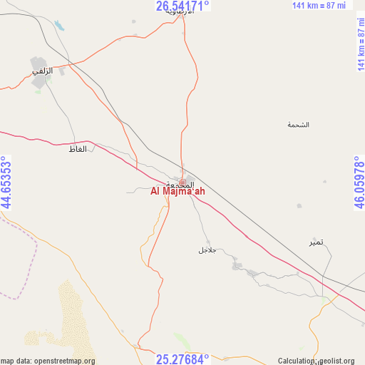
Al Majma‘ah GPS coordinates[2]
25° 54' 39.492" North, 45° 21' 23.94" East
| Map corner | latitude | longitude |
|---|---|---|
| Upper-left | 26.54171°, | 44.65353° |
| Center: | 25.91097°, | 45.35665° |
| Lower-right: | 25.27684°, | 46.05978° |
| Map W x H: | 140.6×140.6 km | = 87.4×87.4mi |
| max Lat: | 31.67252° ⇑38.1% North |
| Al Majma‘ah: | 25.91097° |
| min Lat: | ⇓61.9% South 16.57946° |
| min Long | Al Majma‘ah | max Long |
| 35.69014° | 45.35665° | 54.09599° |
| W 60.8%⇐ | ⇒39.2% E |
Elevation
Elevation of Al Majma‘ah is 712 m = 2336 ft, and this is 190.6 m = 625 ft above average elevation for this country.
| Max E: |
2385 m = 7825 ft | 24.7% |
| Al Majma‘ah | 712 m 2336 ft | |
| Avg. | 521.4 m = 1711 ft | |
Min E: |
3 m = 10 ft | 75.3% |
See also: Saudi Arabia elevation on elevation.city.
Geographical zone
Al Majma‘ah is located in North temperate zone (between Tropic of Cancer and the Arctic Circle). Distance of this Northern Tropic circle is 275.1 km =170.9 mi to South.| Distance of | km | miles | from Al Majma‘ah |
|---|---|---|---|
| North Pole | 7126 | 4427.9 | to North |
| Arctic Circle | 4520.1 | 2808.7 | to North |
| Tropic Cancer | 275.1 | 170.9 | to South |
| Equator | 2881 | 1790.2 | to South |


Nearby cities:
15 places around Al Majma‘ah: (largest is in red/bold)
• Ad Dawādimī
183.7 km =114.1 mi,  211°
211°
• Ain AlBaraha
204.3 km =126.9 mi,  231°
231°
• Al Arţāwīyah
65.9 km =40.9 mi,  359°
359°
• Al Bukayrīyah
171.6 km =106.6 mi,  278°
278°
• Al Mithnab
113.6 km =70.6 mi,  267°
267°
• Ar Rass
186 km =115.6 mi, 268°
• Az Zulfī
69.2 km =43 mi,  308°
308°
• Buraydah
145.5 km =90.4 mi,  288°
288°
• Marāt
94 km =58.4 mi,  173°
173°
• Riyadh
193.2 km =120 mi,  134°
134°
• Sājir
111 km =69 mi,  223°
223°
• Tanūmah
179.7 km =111.7 mi,  317°
317°
• Tumayr
56.2 km =34.9 mi,  114°
114°
• Unaizah
140.6 km =87.4 mi, 278°
• shokhaibٍ
182.7 km =113.5 mi,  149°
149°
Sources, notices
• [Note1] Compared only with cities in Saudi Arabia existing in our database
• [Src1] Map data: © OpenStreetMap contributors (CC-BY-SA)
• [Src2] Other city data from geonames.org with taken over terms of usage.
• [Src3] Geographical zone / Annual Mean Temperature by Robert A. Rohde @ Wikipedia
