Raḩīmah geodata
Raḩīmah (Eastern Province) is a populated place; located in Saudi Arabia in Asia/Riyadh (GMT+3) time zone. With population of 41,188 people, there are 41 cities with bigger population in this country. Compared to other cities in Saudi Arabia, 83.5% of cities are located further ↓South; 95.9% of cities are located further ←West and 92.8% of cities have higher elevation than Raḩīmah. Note1


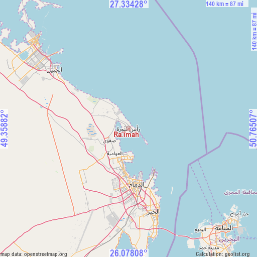
Raḩīmah GPS coordinates[2]
26° 42' 28.476" North, 50° 3' 42.984" East
| Map corner | latitude | longitude |
|---|---|---|
| Upper-left | 27.33428°, | 49.35882° |
| Center: | 26.70791°, | 50.06194° |
| Lower-right: | 26.07808°, | 50.76507° |
| Map W x H: | 139.7×139.7 km | = 86.8×86.8mi |
| max Lat: | 31.67252° ⇑16.5% North |
| Raḩīmah: | 26.70791° |
| min Lat: | ⇓83.5% South 16.57946° |
| min Long | Raḩīmah | max Long |
| 35.69014° | 50.06194° | 54.09599° |
| W 95.9%⇐ | ⇒4.1% E |
Elevation
Elevation of Raḩīmah is 7 m = 23 ft, and this is 514.4 m = 1688 ft below average elevation for this country.
| Max E: |
2385 m = 7825 ft | 92.8% |
| Avg. | 521.4 m = 1711 ft | |
| Raḩīmah | 7 m = 23 ft | |
Min E: |
3 m = 10 ft | 7.2% |
See also: Raḩīmah elevation on elevation.city.
Geographical zone
Raḩīmah is located in North temperate zone (between Tropic of Cancer and the Arctic Circle). Distance of this Northern Tropic circle is 363.7 km =226 mi to South.| Distance of | km | miles | from Raḩīmah |
|---|---|---|---|
| North Pole | 7037.4 | 4372.8 | to North |
| Arctic Circle | 4431.5 | 2753.6 | to North |
| Tropic Cancer | 363.7 | 226 | to South |
| Equator | 2969.6 | 1845.2 | to South |


Nearby cities:
15 places around Raḩīmah: (largest is in red/bold)
• Abqaiq
94.5 km =58.7 mi,  204°
204°
• Al Awjām
19.9 km =12.4 mi,  216°
216°
• Al Jubayl
55.5 km =34.5 mi,  308°
308°
• Al Muţayrifī
145.6 km =90.5 mi, 200°
• Al Qaţīf
16.7 km =10.4 mi, 198°
• Al Qurayn
143.8 km =89.4 mi, 198°
• At Tūbī
18.1 km =11.2 mi, 202°
• Dammam
30.7 km =19.1 mi,  172°
172°
• Dhahran
46.9 km =29.1 mi, 173°
• Julayjilah
142 km =88.2 mi, 198°
• Khobar
49.8 km =30.9 mi,  162°
162°
• Sayhāt
25 km =15.5 mi,  183°
183°
• Tārūt
15.1 km =9.4 mi,  188°
188°
• Umm as Sāhik
15.7 km =9.8 mi,  247°
247°
• Şafwá
12.4 km =7.7 mi,  238°
238°
Sources, notices
• [Note1] Compared only with cities in Saudi Arabia existing in our database
• [Src1] Map data: © OpenStreetMap contributors (CC-BY-SA)
• [Src2] Other city data from geonames.org with taken over terms of usage.
• [Src3] Geographical zone / Annual Mean Temperature by Robert A. Rohde @ Wikipedia
