Markaryd geodata
Markaryd (Kronoberg) is a seat of a second-order administrative division; located in Sweden in Europe/Stockholm (GMT+2) time zone. With population of 4,664 people, there are 290 cities with bigger population in this country. Compared to other cities in Sweden, 84.4% of cities are located further ↑North; 69.4% of cities are located further →East and 73.1% of cities have lower elevation than Markaryd. Note1


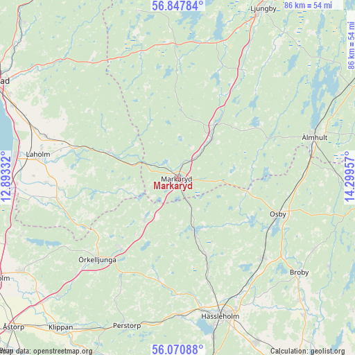
Markaryd GPS coordinates[2]
56° 27' 40.86" North, 13° 35' 47.184" East
| Map corner | latitude | longitude |
|---|---|---|
| Upper-left | 56.84784°, | 12.89332° |
| Center: | 56.46135°, | 13.59644° |
| Lower-right: | 56.07088°, | 14.29957° |
| Map W x H: | 86.4×86.4 km | = 53.7×53.7mi |
| max Lat: | 67.85572° ⇑84.4% North |
| Markaryd: | 56.46135° |
| min Lat: | ⇓15.6% South 55.34337° |
| min Long | Markaryd | max Long |
| 11.1712° | 13.59644° | 24.13676° |
| W 30.6%⇐ | ⇒69.4% E |
Elevation
Elevation of Markaryd is 109 m = 358 ft, and this is 26.4 m = 87 ft above average elevation for this country.
| Max E: |
663 m = 2175 ft | 26.9% |
| Markaryd | 109 m 358 ft | |
| Avg. | 82.6 m = 271 ft | |
Min E: |
-1 m = -3 ft | 73.1% |
See also: Sweden elevation on elevation.city.
Geographical zone
Markaryd is located in North temperate zone (between Tropic of Cancer and the Arctic Circle). Distance of this North polar circle is 1123.3 km =698 mi to North.| Distance of | km | miles | from Markaryd |
|---|---|---|---|
| North Pole | 3729.1 | 2317.2 | to North |
| Arctic Circle | 1123.3 | 698 | to North |
| Tropic Cancer | 3672 | 2281.7 | to South |
| Equator | 6277.9 | 3900.9 | to South |


Nearby cities:
15 places around Markaryd: (largest is in red/bold)
• Arkelstorp
32.1 km =19.9 mi,  154°
154°
• Bjärnum
20.3 km =12.6 mi,  159°
159°
• Hästveda
28.7 km =17.8 mi,  133°
133°
• Killeberg
30.8 km =19.1 mi,  86°
86°
• Knäred
17.9 km =11.1 mi,  290°
290°
• Kyrkhult
22.5 km =14 mi,  295°
295°
• Osby
26 km =16.2 mi,  109°
109°
• Sjörröd
27.9 km =17.3 mi,  135°
135°
• Strömsnäsbruk
12.3 km =7.6 mi,  36°
36°
• Timsfors
2.6 km =1.6 mi,  341°
341°
• Traryd
16.1 km =10 mi, 35°
• Vittsjö
13.7 km =8.5 mi, 163°
• Våxtorp
29.7 km =18.5 mi,  260°
260°
• Åsljunga
21.4 km =13.3 mi,  221°
221°
• Örkelljunga
27.9 km =17.3 mi, 224°
Sources, notices
• [Note1] Compared only with cities in Sweden existing in our database
• [Src1] Map data: © OpenStreetMap contributors (CC-BY-SA)
• [Src2] Other city data from geonames.org with taken over terms of usage.
• [Src3] Geographical zone / Annual Mean Temperature by Robert A. Rohde @ Wikipedia
