Åsljunga geodata
Åsljunga (Skåne) is a populated place; located in Sweden in Europe/Stockholm (GMT+2) time zone. With population of 738 people, there are 1025 cities with bigger population in this country. Compared to other cities in Sweden, 85.8% of cities are located further ↑North; 73.4% of cities are located further →East and 71.6% of cities have lower elevation than Åsljunga. Note1


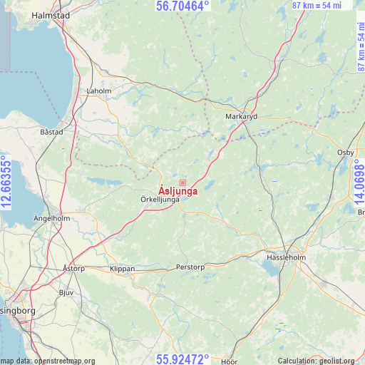
Åsljunga GPS coordinates[2]
56° 19' 0.012" North, 13° 22' 0.012" East
| Map corner | latitude | longitude |
|---|---|---|
| Upper-left | 56.70464°, | 12.66355° |
| Center: | 56.31667°, | 13.36667° |
| Lower-right: | 55.92472°, | 14.0698° |
| Map W x H: | 86.7×86.7 km | = 53.9×53.9mi |
| max Lat: | 67.85572° ⇑85.8% North |
| Åsljunga: | 56.31667° |
| min Lat: | ⇓14.2% South 55.34337° |
| min Long | Åsljunga | max Long |
| 11.1712° | 13.36667° | 24.13676° |
| W 26.6%⇐ | ⇒73.4% E |
Elevation
Elevation of Åsljunga is 104 m = 341 ft, and this is 21.4 m = 70 ft above average elevation for this country.
| Max E: |
663 m = 2175 ft | 28.4% |
| Åsljunga | 104 m 341 ft | |
| Avg. | 82.6 m = 271 ft | |
Min E: |
-1 m = -3 ft | 71.6% |
See also: Sweden elevation on elevation.city.
Geographical zone
Åsljunga is located in North temperate zone (between Tropic of Cancer and the Arctic Circle). Distance of this North polar circle is 1139.3 km =707.9 mi to North.| Distance of | km | miles | from Åsljunga |
|---|---|---|---|
| North Pole | 3745.2 | 2327.2 | to North |
| Arctic Circle | 1139.3 | 707.9 | to North |
| Tropic Cancer | 3655.9 | 2271.7 | to South |
| Equator | 6261.8 | 3890.9 | to South |


Nearby cities:
15 places around Åsljunga: (largest is in red/bold)
• Bjärnum
21.5 km =13.4 mi,  97°
97°
• Finja
25.7 km =16 mi,  130°
130°
• Klippan
24.9 km =15.5 mi,  215°
215°
• Knäred
22.6 km =14 mi,  353°
353°
• Kyrkhult
26.7 km =16.6 mi, 346°
• Markaryd
21.4 km =13.3 mi,  41°
41°
• Munka-Ljungby
25.8 km =16 mi,  253°
253°
• Perstorp
19.9 km =12.4 mi,  174°
174°
• Stidsvig
19.4 km =12.1 mi,  228°
228°
• Timsfors
22.8 km =14.2 mi, 35°
• Tyringe
22.5 km =14 mi,  140°
140°
• Vittsjö
18.4 km =11.4 mi,  80°
80°
• Våxtorp
18.8 km =11.7 mi,  306°
306°
• Örkelljunga
6.6 km =4.1 mi,  235°
235°
• Östra Ljungby
21.6 km =13.4 mi, 231°
Sources, notices
• [Note1] Compared only with cities in Sweden existing in our database
• [Src1] Map data: © OpenStreetMap contributors (CC-BY-SA)
• [Src2] Other city data from geonames.org with taken over terms of usage.
• [Src3] Geographical zone / Annual Mean Temperature by Robert A. Rohde @ Wikipedia
