Örkelljunga geodata
Örkelljunga (Skåne) is a seat of a second-order administrative division; located in Sweden in Europe/Stockholm (GMT+2) time zone. With population of 5,193 people, there are 261 cities with bigger population in this country. Compared to other cities in Sweden, 86.3% of cities are located further ↑North; 74.5% of cities are located further →East and 60.4% of cities have lower elevation than Örkelljunga. Note1


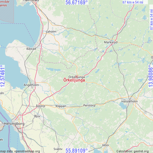
Örkelljunga GPS coordinates[2]
56° 17' 0.168" North, 13° 16' 39.828" East
| Map corner | latitude | longitude |
|---|---|---|
| Upper-left | 56.67169°, | 12.57461° |
| Center: | 56.28338°, | 13.27773° |
| Lower-right: | 55.89109°, | 13.98086° |
| Map W x H: | 86.8×86.8 km | = 53.9×53.9mi |
| max Lat: | 67.85572° ⇑86.3% North |
| Örkelljunga: | 56.28338° |
| min Lat: | ⇓13.7% South 55.34337° |
| min Long | Örkelljunga | max Long |
| 11.1712° | 13.27773° | 24.13676° |
| W 25.5%⇐ | ⇒74.5% E |
Elevation
Elevation of Örkelljunga is 72 m = 236 ft, and this is 10.6 m = 35 ft below average elevation for this country.
| Max E: |
663 m = 2175 ft | 39.6% |
| Avg. | 82.6 m = 271 ft | |
| Örkelljunga | 72 m = 236 ft | |
Min E: |
-1 m = -3 ft | 60.4% |
See also: Sweden elevation on elevation.city.
Geographical zone
Örkelljunga is located in North temperate zone (between Tropic of Cancer and the Arctic Circle). Distance of this North polar circle is 1143 km =710.2 mi to North.| Distance of | km | miles | from Örkelljunga |
|---|---|---|---|
| North Pole | 3748.9 | 2329.5 | to North |
| Arctic Circle | 1143 | 710.2 | to North |
| Tropic Cancer | 3652.2 | 2269.4 | to South |
| Equator | 6258.1 | 3888.6 | to South |


Nearby cities:
15 places around Örkelljunga: (largest is in red/bold)
• Björnås
26.2 km =16.3 mi,  227°
227°
• Hjärnarp
22.6 km =14 mi,  279°
279°
• Klippan
18.8 km =11.7 mi,  208°
208°
• Kvidinge
21.9 km =13.6 mi,  220°
220°
• Ljungbyhed
23.4 km =14.5 mi,  185°
185°
• Munka-Ljungby
19.6 km =12.2 mi,  259°
259°
• Perstorp
17.7 km =11 mi,  155°
155°
• Stidsvig
12.9 km =8 mi, 223°
• Tyringe
24.1 km =15 mi,  124°
124°
• Vallberga
26 km =16.2 mi,  321°
321°
• Vittsjö
24.6 km =15.3 mi,  74°
74°
• Våxtorp
17.7 km =11 mi,  326°
326°
• Ängelholm
26.1 km =16.2 mi, 260°
• Åsljunga
6.6 km =4.1 mi,  55°
55°
• Östra Ljungby
15 km =9.3 mi, 229°
Sources, notices
• [Note1] Compared only with cities in Sweden existing in our database
• [Src1] Map data: © OpenStreetMap contributors (CC-BY-SA)
• [Src2] Other city data from geonames.org with taken over terms of usage.
• [Src3] Geographical zone / Annual Mean Temperature by Robert A. Rohde @ Wikipedia
