Vikmanshyttan geodata
Vikmanshyttan (Dalarna) is a populated place; located in Sweden in Europe/Stockholm (GMT+2) time zone. With population of 840 people, there are 935 cities with bigger population in this country. Compared to other cities in Sweden, 76.9% of cities are located further ↓South; 59.6% of cities are located further ←West and 74.4% of cities have lower elevation than Vikmanshyttan. Note1


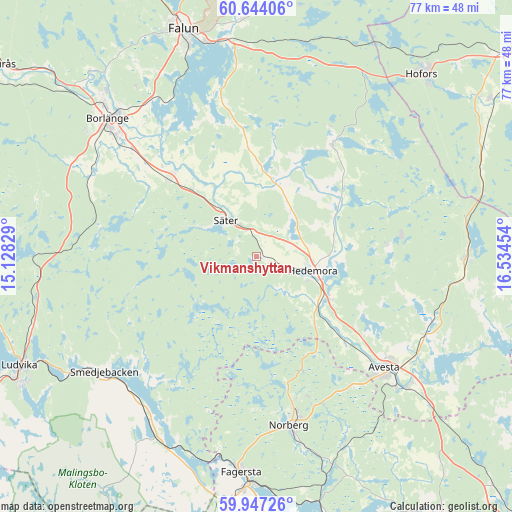
Vikmanshyttan GPS coordinates[2]
60° 17' 51.072" North, 15° 49' 53.076" East
| Map corner | latitude | longitude |
|---|---|---|
| Upper-left | 60.64406°, | 15.12829° |
| Center: | 60.29752°, | 15.83141° |
| Lower-right: | 59.94726°, | 16.53454° |
| Map W x H: | 77.5×77.5 km | = 48.2×48.2mi |
| max Lat: | 67.85572° ⇑23.1% North |
| Vikmanshyttan: | 60.29752° |
| min Lat: | ⇓76.9% South 55.34337° |
| min Long | Vikmanshyttan | max Long |
| 11.1712° | 15.83141° | 24.13676° |
| W 59.6%⇐ | ⇒40.4% E |
Elevation
Elevation of Vikmanshyttan is 116 m = 381 ft, and this is 33.4 m = 110 ft above average elevation for this country.
| Max E: |
663 m = 2175 ft | 25.6% |
| Vikmanshyttan | 116 m 381 ft | |
| Avg. | 82.6 m = 271 ft | |
Min E: |
-1 m = -3 ft | 74.4% |
See also: Sweden elevation on elevation.city.
Geographical zone
Vikmanshyttan is located in North temperate zone (between Tropic of Cancer and the Arctic Circle). Distance of this North polar circle is 696.7 km =432.9 mi to North.| Distance of | km | miles | from Vikmanshyttan |
|---|---|---|---|
| North Pole | 3302.6 | 2052.1 | to North |
| Arctic Circle | 696.7 | 432.9 | to North |
| Tropic Cancer | 4098.5 | 2546.7 | to South |
| Equator | 6704.5 | 4166 | to South |


Nearby cities:
15 places around Vikmanshyttan: (largest is in red/bold)
• Avesta
25.1 km =15.6 mi,  133°
133°
• Brunna
10.6 km =6.6 mi,  111°
111°
• Enbacka
18 km =11.2 mi,  313°
313°
• Fors
28.1 km =17.5 mi, 110°
• Garpenberg
20.4 km =12.7 mi,  84°
84°
• Hedemora
8.9 km =5.5 mi,  102°
102°
• Krylbo
28 km =17.4 mi, 130°
• Långshyttan
20.6 km =12.8 mi,  33°
33°
• Mora
17.1 km =10.6 mi, 311°
• Norberg
26.3 km =16.3 mi,  168°
168°
• Romme
23.7 km =14.7 mi, 309°
• Säter
7.1 km =4.4 mi,  321°
321°
• Tomtebo
14.7 km =9.1 mi,  334°
334°
• Torsång
23.8 km =14.8 mi, 322°
• Vika
24.8 km =15.4 mi,  345°
345°
Sources, notices
• [Note1] Compared only with cities in Sweden existing in our database
• [Src1] Map data: © OpenStreetMap contributors (CC-BY-SA)
• [Src2] Other city data from geonames.org with taken over terms of usage.
• [Src3] Geographical zone / Annual Mean Temperature by Robert A. Rohde @ Wikipedia
