Avesta geodata
Avesta (Dalarna) is a seat of a second-order administrative division; located in Sweden in Europe/Stockholm (GMT+2) time zone. With population of 11,949 people, there are 130 cities with bigger population in this country. Compared to other cities in Sweden, 75% of cities are located further ↓South; 63.2% of cities are located further ←West and 66.8% of cities have lower elevation than Avesta. Note1
Administrative division(s):
- Level 1: Dalarna
- Level 2: Avesta Kommun
- Level 3: Avesta
- Level 4: Avesta socken


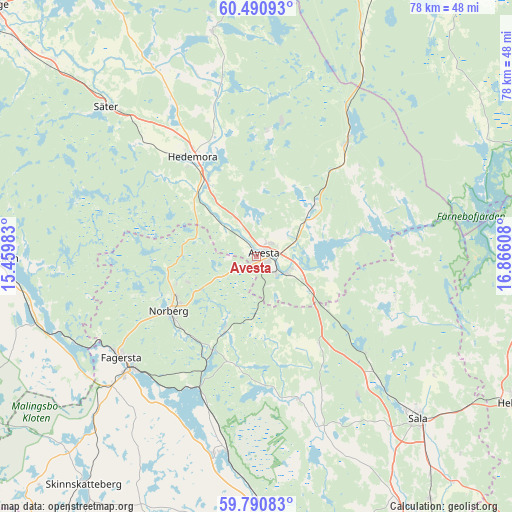
Avesta GPS coordinates[2]
60° 8' 33.864" North, 16° 9' 46.62" East
| Map corner | latitude | longitude |
|---|---|---|
| Upper-left | 60.49093°, | 15.45983° |
| Center: | 60.14274°, | 16.16295° |
| Lower-right: | 59.79083°, | 16.86608° |
| Map W x H: | 77.8×77.8 km | = 48.3×48.3mi |
| max Lat: | 67.85572° ⇑25% North |
| Avesta: | 60.14274° |
| min Lat: | ⇓75% South 55.34337° |
| min Long | Avesta | max Long |
| 11.1712° | 16.16295° | 24.13676° |
| W 63.2%⇐ | ⇒36.8% E |
Elevation
Elevation of Avesta is 89 m = 292 ft, and this is 6.4 m = 21 ft above average elevation for this country.
| Max E: |
663 m = 2175 ft | 33.2% |
| Avesta | 89 m 292 ft | |
| Avg. | 82.6 m = 271 ft | |
Min E: |
-1 m = -3 ft | 66.8% |
See also: Sweden elevation on elevation.city.
Geographical zone
Avesta is located in North temperate zone (between Tropic of Cancer and the Arctic Circle). Distance of this North polar circle is 713.9 km =443.6 mi to North.| Distance of | km | miles | from Avesta |
|---|---|---|---|
| North Pole | 3319.8 | 2062.8 | to North |
| Arctic Circle | 713.9 | 443.6 | to North |
| Tropic Cancer | 4081.3 | 2536 | to South |
| Equator | 6687.2 | 4155.2 | to South |


Nearby cities:
15 places around Avesta: (largest is in red/bold)
• Annelund
17.4 km =10.8 mi,  204°
204°
• Brunna
15.8 km =9.8 mi,  327°
327°
• Fagersta
25.7 km =16 mi,  233°
233°
• Fors
10.8 km =6.7 mi,  47°
47°
• Garpenberg
19.4 km =12.1 mi,  6°
6°
• Hedemora
18 km =11.2 mi, 327°
• Horndal
22.4 km =13.9 mi,  38°
38°
• Krylbo
3.2 km =2 mi,  109°
109°
• Norberg
15.8 km =9.8 mi,  236°
236°
• Råby
12.2 km =7.6 mi, 112°
• Sjövik
8.5 km =5.3 mi,  84°
84°
• Säter
32.2 km =20 mi,  315°
315°
• Söderbärke
34.4 km =21.4 mi,  256°
256°
• Vikmanshyttan
25.1 km =15.6 mi,  313°
313°
• Västerfärnebo
22.8 km =14.2 mi,  163°
163°
Sources, notices
• [Note1] Compared only with cities in Sweden existing in our database
• [Src1] Map data: © OpenStreetMap contributors (CC-BY-SA)
• [Src2] Other city data from geonames.org with taken over terms of usage.
• [Src3] Geographical zone / Annual Mean Temperature by Robert A. Rohde @ Wikipedia
