Hedemora geodata
Hedemora (Dalarna) is a seat of a second-order administrative division; located in Sweden in Europe/Stockholm (GMT+2) time zone. With population of 7,371 people, there are 199 cities with bigger population in this country. Compared to other cities in Sweden, 76.8% of cities are located further ↓South; 61.6% of cities are located further ←West and 70.8% of cities have lower elevation than Hedemora. Note1


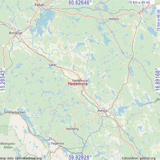
Hedemora GPS coordinates[2]
60° 16' 47.028" North, 15° 59' 18.78" East
| Map corner | latitude | longitude |
|---|---|---|
| Upper-left | 60.62646°, | 15.28543° |
| Center: | 60.27973°, | 15.98855° |
| Lower-right: | 59.92928°, | 16.69168° |
| Map W x H: | 77.5×77.5 km | = 48.2×48.2mi |
| max Lat: | 67.85572° ⇑23.2% North |
| Hedemora: | 60.27973° |
| min Lat: | ⇓76.8% South 55.34337° |
| min Long | Hedemora | max Long |
| 11.1712° | 15.98855° | 24.13676° |
| W 61.6%⇐ | ⇒38.4% E |
Elevation
Elevation of Hedemora is 101 m = 331 ft, and this is 18.4 m = 60 ft above average elevation for this country.
| Max E: |
663 m = 2175 ft | 29.2% |
| Hedemora | 101 m 331 ft | |
| Avg. | 82.6 m = 271 ft | |
Min E: |
-1 m = -3 ft | 70.8% |
See also: Sweden elevation on elevation.city.
Geographical zone
Hedemora is located in North temperate zone (between Tropic of Cancer and the Arctic Circle). Distance of this North polar circle is 698.7 km =434.2 mi to North.| Distance of | km | miles | from Hedemora |
|---|---|---|---|
| North Pole | 3304.6 | 2053.4 | to North |
| Arctic Circle | 698.7 | 434.2 | to North |
| Tropic Cancer | 4096.6 | 2545.5 | to South |
| Equator | 6702.5 | 4164.7 | to South |


Nearby cities:
15 places around Hedemora: (largest is in red/bold)
• Avesta
18 km =11.2 mi,  147°
147°
• Brunna
2.3 km =1.4 mi, 147°
• Enbacka
26 km =16.2 mi,  303°
303°
• Fors
19.4 km =12.1 mi,  114°
114°
• Garpenberg
12.4 km =7.7 mi,  70°
70°
• Horndal
23.7 km =14.7 mi,  84°
84°
• Krylbo
20.6 km =12.8 mi,  142°
142°
• Långshyttan
19.4 km =12.1 mi,  8°
8°
• Mora
25.2 km =15.7 mi, 302°
• Norberg
24.1 km =15 mi,  188°
188°
• Råby
28.9 km =18 mi,  133°
133°
• Sjövik
23.2 km =14.4 mi, 128°
• Säter
15.1 km =9.4 mi, 299°
• Tomtebo
21.3 km =13.2 mi,  315°
315°
• Vikmanshyttan
8.9 km =5.5 mi,  282°
282°
Sources, notices
• [Note1] Compared only with cities in Sweden existing in our database
• [Src1] Map data: © OpenStreetMap contributors (CC-BY-SA)
• [Src2] Other city data from geonames.org with taken over terms of usage.
• [Src3] Geographical zone / Annual Mean Temperature by Robert A. Rohde @ Wikipedia
