Garpenberg geodata
Garpenberg (Dalarna) is a populated place; located in Sweden in Europe/Stockholm (GMT+2) time zone. With population of 515 people, there are 1294 cities with bigger population in this country. Compared to other cities in Sweden, 77.1% of cities are located further ↓South; 63.9% of cities are located further ←West and 77.5% of cities have lower elevation than Garpenberg. Note1


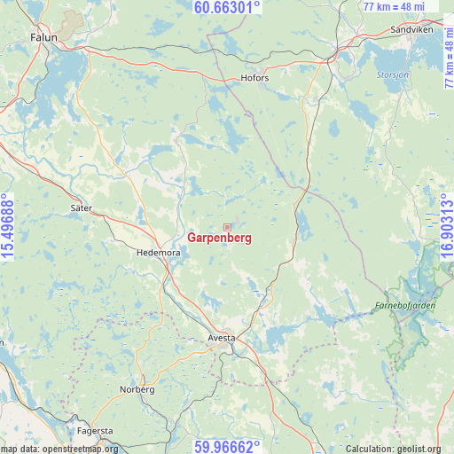
Garpenberg GPS coordinates[2]
60° 19' 0.012" North, 16° 12' 0" East
| Map corner | latitude | longitude |
|---|---|---|
| Upper-left | 60.66301°, | 15.49688° |
| Center: | 60.31667°, | 16.2° |
| Lower-right: | 59.96662°, | 16.90313° |
| Map W x H: | 77.4×77.4 km | = 48.1×48.1mi |
| max Lat: | 67.85572° ⇑22.9% North |
| Garpenberg: | 60.31667° |
| min Lat: | ⇓77.1% South 55.34337° |
| min Long | Garpenberg | max Long |
| 11.1712° | 16.2° | 24.13676° |
| W 63.9%⇐ | ⇒36.1% E |
Elevation
Elevation of Garpenberg is 130 m = 427 ft, and this is 47.4 m = 156 ft above average elevation for this country.
| Max E: |
663 m = 2175 ft | 22.5% |
| Garpenberg | 130 m 427 ft | |
| Avg. | 82.6 m = 271 ft | |
Min E: |
-1 m = -3 ft | 77.5% |
See also: Sweden elevation on elevation.city.
Geographical zone
Garpenberg is located in North temperate zone (between Tropic of Cancer and the Arctic Circle). Distance of this North polar circle is 694.6 km =431.6 mi to North.| Distance of | km | miles | from Garpenberg |
|---|---|---|---|
| North Pole | 3300.5 | 2050.8 | to North |
| Arctic Circle | 694.6 | 431.6 | to North |
| Tropic Cancer | 4100.7 | 2548.1 | to South |
| Equator | 6706.6 | 4167.3 | to South |


Nearby cities:
15 places around Garpenberg: (largest is in red/bold)
• Avesta
19.4 km =12.1 mi,  186°
186°
• Brunna
12.1 km =7.5 mi,  240°
240°
• Fors
13.5 km =8.4 mi,  153°
153°
• Hedemora
12.4 km =7.7 mi,  250°
250°
• Hofors
25.9 km =16.1 mi,  10°
10°
• Horndal
12.1 km =7.5 mi,  98°
98°
• Krylbo
20.4 km =12.7 mi,  177°
177°
• Långshyttan
17.5 km =10.9 mi,  329°
329°
• Norberg
31.9 km =19.8 mi,  208°
208°
• Råby
25.8 km =16 mi,  159°
159°
• Sjövik
19.6 km =12.2 mi, 160°
• Säter
25 km =15.5 mi,  277°
277°
• Tomtebo
28.8 km =17.9 mi,  292°
292°
• Torsåker
26.2 km =16.3 mi,  34°
34°
• Vikmanshyttan
20.4 km =12.7 mi,  264°
264°
Sources, notices
• [Note1] Compared only with cities in Sweden existing in our database
• [Src1] Map data: © OpenStreetMap contributors (CC-BY-SA)
• [Src2] Other city data from geonames.org with taken over terms of usage.
• [Src3] Geographical zone / Annual Mean Temperature by Robert A. Rohde @ Wikipedia
