Långshyttan geodata
Långshyttan (Dalarna) is a populated place; located in Sweden in Europe/Stockholm (GMT+2) time zone. With population of 1,609 people, there are 618 cities with bigger population in this country. Compared to other cities in Sweden, 77.9% of cities are located further ↓South; 62.4% of cities are located further ←West and 71.6% of cities have lower elevation than Långshyttan. Note1


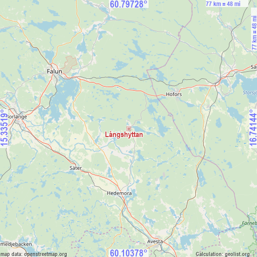
Långshyttan GPS coordinates[2]
60° 27' 8.568" North, 16° 2' 17.916" East
| Map corner | latitude | longitude |
|---|---|---|
| Upper-left | 60.79728°, | 15.33519° |
| Center: | 60.45238°, | 16.03831° |
| Lower-right: | 60.10378°, | 16.74144° |
| Map W x H: | 77.1×77.1 km | = 47.9×47.9mi |
| max Lat: | 67.85572° ⇑22.1% North |
| Långshyttan: | 60.45238° |
| min Lat: | ⇓77.9% South 55.34337° |
| min Long | Långshyttan | max Long |
| 11.1712° | 16.03831° | 24.13676° |
| W 62.4%⇐ | ⇒37.6% E |
Elevation
Elevation of Långshyttan is 104 m = 341 ft, and this is 21.4 m = 70 ft above average elevation for this country.
| Max E: |
663 m = 2175 ft | 28.4% |
| Långshyttan | 104 m 341 ft | |
| Avg. | 82.6 m = 271 ft | |
Min E: |
-1 m = -3 ft | 71.6% |
See also: Sweden elevation on elevation.city.
Geographical zone
Långshyttan is located in North temperate zone (between Tropic of Cancer and the Arctic Circle). Distance of this North polar circle is 679.5 km =422.2 mi to North.| Distance of | km | miles | from Långshyttan |
|---|---|---|---|
| North Pole | 3285.4 | 2041.5 | to North |
| Arctic Circle | 679.5 | 422.2 | to North |
| Tropic Cancer | 4115.8 | 2557.4 | to South |
| Equator | 6721.7 | 4176.7 | to South |


Nearby cities:
15 places around Långshyttan: (largest is in red/bold)
• Brunna
21.2 km =13.2 mi,  184°
184°
• Enbacka
24.7 km =15.3 mi,  259°
259°
• Garpenberg
17.5 km =10.9 mi,  149°
149°
• Hedemora
19.4 km =12.1 mi,  188°
188°
• Hofors
17.1 km =10.6 mi,  52°
52°
• Horndal
26.8 km =16.7 mi,  129°
129°
• Mora
24.7 km =15.3 mi, 256°
• Ornäs
28 km =17.4 mi,  283°
283°
• Sundborn
26.5 km =16.5 mi,  325°
325°
• Säter
19.6 km =12.2 mi,  233°
233°
• Tomtebo
18.1 km =11.2 mi, 257°
• Torsåker
24.6 km =15.3 mi,  74°
74°
• Torsång
25.9 km =16.1 mi,  273°
273°
• Vika
18.9 km =11.7 mi,  291°
291°
• Vikmanshyttan
20.6 km =12.8 mi,  213°
213°
Sources, notices
• [Note1] Compared only with cities in Sweden existing in our database
• [Src1] Map data: © OpenStreetMap contributors (CC-BY-SA)
• [Src2] Other city data from geonames.org with taken over terms of usage.
• [Src3] Geographical zone / Annual Mean Temperature by Robert A. Rohde @ Wikipedia
