Krylbo geodata
Krylbo (Dalarna) is a populated place; located in Sweden in Europe/Stockholm (GMT+2) time zone. With population of 4,072 people, there are 316 cities with bigger population in this country. Compared to other cities in Sweden, 74.7% of cities are located further ↓South; 64.4% of cities are located further ←West and 58.6% of cities have lower elevation than Krylbo. Note1


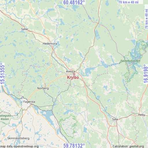
Krylbo GPS coordinates[2]
60° 7' 59.988" North, 16° 13' 0.012" East
| Map corner | latitude | longitude |
|---|---|---|
| Upper-left | 60.48162°, | 15.51355° |
| Center: | 60.13333°, | 16.21667° |
| Lower-right: | 59.78132°, | 16.9198° |
| Map W x H: | 77.9×77.9 km | = 48.4×48.4mi |
| max Lat: | 67.85572° ⇑25.3% North |
| Krylbo: | 60.13333° |
| min Lat: | ⇓74.7% South 55.34337° |
| min Long | Krylbo | max Long |
| 11.1712° | 16.21667° | 24.13676° |
| W 64.4%⇐ | ⇒35.6% E |
Elevation
Elevation of Krylbo is 66 m = 217 ft, and this is 16.6 m = 54 ft below average elevation for this country.
| Max E: |
663 m = 2175 ft | 41.4% |
| Avg. | 82.6 m = 271 ft | |
| Krylbo | 66 m = 217 ft | |
Min E: |
-1 m = -3 ft | 58.6% |
See also: Sweden elevation on elevation.city.
Geographical zone
Krylbo is located in North temperate zone (between Tropic of Cancer and the Arctic Circle). Distance of this North polar circle is 715 km =444.3 mi to North.| Distance of | km | miles | from Krylbo |
|---|---|---|---|
| North Pole | 3320.9 | 2063.5 | to North |
| Arctic Circle | 715 | 444.3 | to North |
| Tropic Cancer | 4080.3 | 2535.4 | to South |
| Equator | 6686.2 | 4154.6 | to South |


Nearby cities:
15 places around Krylbo: (largest is in red/bold)
• Annelund
18 km =11.2 mi,  214°
214°
• Avesta
3.2 km =2 mi,  289°
289°
• Brunna
18.3 km =11.4 mi,  321°
321°
• Fagersta
27.5 km =17.1 mi,  238°
238°
• Fors
9.7 km =6 mi,  31°
31°
• Garpenberg
20.4 km =12.7 mi,  357°
357°
• Hedemora
20.6 km =12.8 mi, 322°
• Horndal
21.6 km =13.4 mi, 30°
• Norberg
17.9 km =11.1 mi, 244°
• Råby
9.1 km =5.7 mi,  114°
114°
• Sala
32.1 km =19.9 mi,  137°
137°
• Sjövik
5.8 km =3.6 mi,  71°
71°
• Säter
35.1 km =21.8 mi,  312°
312°
• Vikmanshyttan
28 km =17.4 mi, 310°
• Västerfärnebo
21.1 km =13.1 mi,  170°
170°
Sources, notices
• [Note1] Compared only with cities in Sweden existing in our database
• [Src1] Map data: © OpenStreetMap contributors (CC-BY-SA)
• [Src2] Other city data from geonames.org with taken over terms of usage.
• [Src3] Geographical zone / Annual Mean Temperature by Robert A. Rohde @ Wikipedia
