Vikingstad geodata
Vikingstad (Östergötland) is a populated place; located in Sweden in Europe/Stockholm (GMT+2) time zone. With population of 2,335 people, there are 474 cities with bigger population in this country. Compared to other cities in Sweden, 55.1% of cities are located further ↑North; 54.8% of cities are located further ←West and 66.1% of cities have lower elevation than Vikingstad. Note1


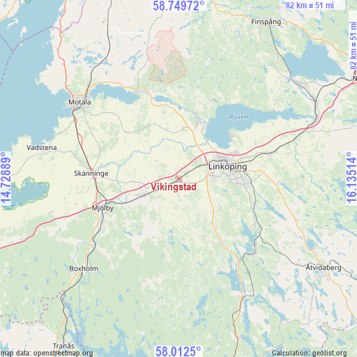
Vikingstad GPS coordinates[2]
58° 22' 58.944" North, 15° 25' 55.236" East
| Map corner | latitude | longitude |
|---|---|---|
| Upper-left | 58.74972°, | 14.72889° |
| Center: | 58.38304°, | 15.43201° |
| Lower-right: | 58.0125°, | 16.13514° |
| Map W x H: | 82×82 km | = 51×51mi |
| max Lat: | 67.85572° ⇑55.1% North |
| Vikingstad: | 58.38304° |
| min Lat: | ⇓44.9% South 55.34337° |
| min Long | Vikingstad | max Long |
| 11.1712° | 15.43201° | 24.13676° |
| W 54.8%⇐ | ⇒45.2% E |
Elevation
Elevation of Vikingstad is 86 m = 282 ft, and this is 3.4 m = 11 ft above average elevation for this country.
| Max E: |
663 m = 2175 ft | 33.9% |
| Vikingstad | 86 m 282 ft | |
| Avg. | 82.6 m = 271 ft | |
Min E: |
-1 m = -3 ft | 66.1% |
See also: Sweden elevation on elevation.city.
Geographical zone
Vikingstad is located in North temperate zone (between Tropic of Cancer and the Arctic Circle). Distance of this North polar circle is 909.6 km =565.2 mi to North.| Distance of | km | miles | from Vikingstad |
|---|---|---|---|
| North Pole | 3515.5 | 2184.4 | to North |
| Arctic Circle | 909.6 | 565.2 | to North |
| Tropic Cancer | 3885.7 | 2414.5 | to South |
| Equator | 6491.6 | 4033.7 | to South |


Nearby cities:
15 places around Vikingstad: (largest is in red/bold)
• Berg
13 km =8.1 mi,  25°
25°
• Bestorp
24.2 km =15 mi,  133°
133°
• Borensberg
22.2 km =13.8 mi,  337°
337°
• Ekängen
15 km =9.3 mi,  51°
51°
• Linghem
21.2 km =13.2 mi,  74°
74°
• Linköping
11.5 km =7.1 mi, 74°
• Ljungsbro
15.4 km =9.6 mi,  14°
14°
• Malmslätt
5.8 km =3.6 mi,  57°
57°
• Mantorp
9.4 km =5.8 mi,  247°
247°
• Mjölby
19.1 km =11.9 mi, 250°
• Skänninge
20.2 km =12.6 mi,  273°
273°
• Slaka
7.1 km =4.4 mi,  104°
104°
• Stenstorp
24 km =14.9 mi,  297°
297°
• Sturefors
18.4 km =11.4 mi,  107°
107°
• Tallboda
15.3 km =9.5 mi, 72°
Sources, notices
• [Note1] Compared only with cities in Sweden existing in our database
• [Src1] Map data: © OpenStreetMap contributors (CC-BY-SA)
• [Src2] Other city data from geonames.org with taken over terms of usage.
• [Src3] Geographical zone / Annual Mean Temperature by Robert A. Rohde @ Wikipedia
