Borensberg geodata
Borensberg (Östergötland) is a populated place; located in Sweden in Europe/Stockholm (GMT+2) time zone. With population of 2,942 people, there are 411 cities with bigger population in this country. Compared to other cities in Sweden, 51.4% of cities are located further ↑North; 53.1% of cities are located further ←West and 72.3% of cities have lower elevation than Borensberg. Note1


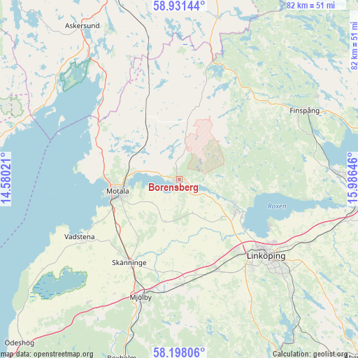
Borensberg GPS coordinates[2]
58° 34' 0.012" North, 15° 16' 59.988" East
| Map corner | latitude | longitude |
|---|---|---|
| Upper-left | 58.93144°, | 14.58021° |
| Center: | 58.56667°, | 15.28333° |
| Lower-right: | 58.19806°, | 15.98646° |
| Map W x H: | 81.5×81.5 km | = 50.6×50.6mi |
| max Lat: | 67.85572° ⇑51.4% North |
| Borensberg: | 58.56667° |
| min Lat: | ⇓48.6% South 55.34337° |
| min Long | Borensberg | max Long |
| 11.1712° | 15.28333° | 24.13676° |
| W 53.1%⇐ | ⇒46.9% E |
Elevation
Elevation of Borensberg is 107 m = 351 ft, and this is 24.4 m = 80 ft above average elevation for this country.
| Max E: |
663 m = 2175 ft | 27.7% |
| Borensberg | 107 m 351 ft | |
| Avg. | 82.6 m = 271 ft | |
Min E: |
-1 m = -3 ft | 72.3% |
See also: Sweden elevation on elevation.city.
Geographical zone
Borensberg is located in North temperate zone (between Tropic of Cancer and the Arctic Circle). Distance of this North polar circle is 889.2 km =552.5 mi to North.| Distance of | km | miles | from Borensberg |
|---|---|---|---|
| North Pole | 3495.1 | 2171.8 | to North |
| Arctic Circle | 889.2 | 552.5 | to North |
| Tropic Cancer | 3906.1 | 2427.1 | to South |
| Equator | 6512 | 4046.4 | to South |


Nearby cities:
15 places around Borensberg: (largest is in red/bold)
• Berg
16.7 km =10.4 mi,  121°
121°
• Ekängen
23.2 km =14.4 mi, 118°
• Linköping
26.2 km =16.3 mi,  131°
131°
• Ljungsbro
13.7 km =8.5 mi,  113°
113°
• Malmslätt
22 km =13.7 mi,  141°
141°
• Mantorp
24.1 km =15 mi,  180°
180°
• Motala
14.7 km =9.1 mi,  257°
257°
• Ryd
16.1 km =10 mi,  313°
313°
• Skänninge
22.3 km =13.9 mi,  210°
210°
• Slaka
27.1 km =16.8 mi,  145°
145°
• Stenstorp
15.6 km =9.7 mi,  233°
233°
• Tallboda
28 km =17.4 mi, 124°
• Tjällmo
17.1 km =10.6 mi,  13°
13°
• Vadstena
26.4 km =16.4 mi,  240°
240°
• Vikingstad
22.2 km =13.8 mi,  157°
157°
Sources, notices
• [Note1] Compared only with cities in Sweden existing in our database
• [Src1] Map data: © OpenStreetMap contributors (CC-BY-SA)
• [Src2] Other city data from geonames.org with taken over terms of usage.
• [Src3] Geographical zone / Annual Mean Temperature by Robert A. Rohde @ Wikipedia
