Skänninge geodata
Skänninge (Östergötland) is a populated place; located in Sweden in Europe/Stockholm (GMT+2) time zone. With population of 3,358 people, there are 373 cities with bigger population in this country. Compared to other cities in Sweden, 54.4% of cities are located further ↑North; 50.8% of cities are located further ←West and 70.5% of cities have lower elevation than Skänninge. Note1
Administrative division(s):
- Level 1: Östergötland
- Level 2: Mjölby Kommun
- Level 3: Skänninge-Allhelgona
- Level 4: Skänninge socken


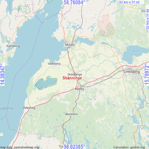
Skänninge GPS coordinates[2]
58° 23' 39.372" North, 15° 5' 11.724" East
| Map corner | latitude | longitude |
|---|---|---|
| Upper-left | 58.76084°, | 14.38347° |
| Center: | 58.39427°, | 15.08659° |
| Lower-right: | 58.02385°, | 15.78972° |
| Map W x H: | 81.9×81.9 km | = 50.9×50.9mi |
| max Lat: | 67.85572° ⇑54.4% North |
| Skänninge: | 58.39427° |
| min Lat: | ⇓45.6% South 55.34337° |
| min Long | Skänninge | max Long |
| 11.1712° | 15.08659° | 24.13676° |
| W 50.8%⇐ | ⇒49.2% E |
Elevation
Elevation of Skänninge is 100 m = 328 ft, and this is 17.4 m = 57 ft above average elevation for this country.
| Max E: |
663 m = 2175 ft | 29.5% |
| Skänninge | 100 m 328 ft | |
| Avg. | 82.6 m = 271 ft | |
Min E: |
-1 m = -3 ft | 70.5% |
See also: Sweden elevation on elevation.city.
Geographical zone
Skänninge is located in North temperate zone (between Tropic of Cancer and the Arctic Circle). Distance of this North polar circle is 908.3 km =564.4 mi to North.| Distance of | km | miles | from Skänninge |
|---|---|---|---|
| North Pole | 3514.2 | 2183.6 | to North |
| Arctic Circle | 908.3 | 564.4 | to North |
| Tropic Cancer | 3886.9 | 2415.2 | to South |
| Equator | 6492.8 | 4034.4 | to South |


Nearby cities:
15 places around Skänninge: (largest is in red/bold)
• Berg
27.8 km =17.3 mi,  67°
67°
• Borensberg
22.3 km =13.9 mi,  30°
30°
• Boxholm
22 km =13.7 mi,  185°
185°
• Herrestad
16.7 km =10.4 mi,  265°
265°
• Ljungsbro
27.6 km =17.1 mi,  60°
60°
• Malmslätt
25.1 km =15.6 mi,  85°
85°
• Mantorp
12.5 km =7.8 mi,  113°
113°
• Mjölby
7.9 km =4.9 mi,  164°
164°
• Motala
16.1 km =10 mi,  349°
349°
• Slaka
27.2 km =16.9 mi,  96°
96°
• Sommen
29.8 km =18.5 mi, 193°
• Stenstorp
10 km =6.2 mi, 353°
• Vadstena
13 km =8.1 mi,  297°
297°
• Vikingstad
20.2 km =12.6 mi, 93°
• Väderstad
13.1 km =8.1 mi,  228°
228°
Sources, notices
• [Note1] Compared only with cities in Sweden existing in our database
• [Src1] Map data: © OpenStreetMap contributors (CC-BY-SA)
• [Src2] Other city data from geonames.org with taken over terms of usage.
• [Src3] Geographical zone / Annual Mean Temperature by Robert A. Rohde @ Wikipedia
