Berg geodata
Berg (Östergötland) is a populated place; located in Sweden in Europe/Stockholm (GMT+2) time zone. With population of 1,229 people, there are 732 cities with bigger population in this country. Compared to other cities in Sweden, 53% of cities are located further ↑North; 55.8% of cities are located further ←West and 55.6% of cities have lower elevation than Berg. Note1


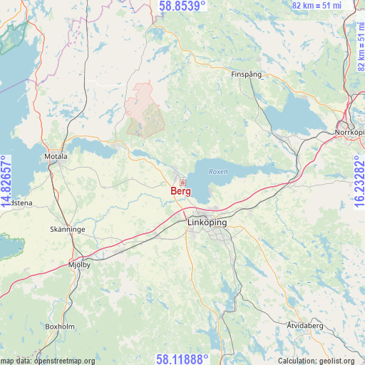
Berg GPS coordinates[2]
58° 29' 17.916" North, 15° 31' 46.884" East
| Map corner | latitude | longitude |
|---|---|---|
| Upper-left | 58.8539°, | 14.82657° |
| Center: | 58.48831°, | 15.52969° |
| Lower-right: | 58.11888°, | 16.23282° |
| Map W x H: | 81.7×81.7 km | = 50.8×50.8mi |
| max Lat: | 67.85572° ⇑53% North |
| Berg: | 58.48831° |
| min Lat: | ⇓47% South 55.34337° |
| min Long | Berg | max Long |
| 11.1712° | 15.52969° | 24.13676° |
| W 55.8%⇐ | ⇒44.2% E |
Elevation
Elevation of Berg is 60 m = 197 ft, and this is 22.6 m = 74 ft below average elevation for this country.
| Max E: |
663 m = 2175 ft | 44.4% |
| Avg. | 82.6 m = 271 ft | |
| Berg | 60 m = 197 ft | |
Min E: |
-1 m = -3 ft | 55.6% |
See also: Sweden elevation on elevation.city.
Geographical zone
Berg is located in North temperate zone (between Tropic of Cancer and the Arctic Circle). Distance of this North polar circle is 897.9 km =557.9 mi to North.| Distance of | km | miles | from Berg |
|---|---|---|---|
| North Pole | 3503.8 | 2177.2 | to North |
| Arctic Circle | 897.9 | 557.9 | to North |
| Tropic Cancer | 3897.4 | 2421.7 | to South |
| Equator | 6503.3 | 4041 | to South |


Nearby cities:
15 places around Berg: (largest is in red/bold)
• Askeby
20.6 km =12.8 mi,  115°
115°
• Borensberg
16.7 km =10.4 mi,  301°
301°
• Ekängen
6.5 km =4 mi,  111°
111°
• Linghem
16 km =9.9 mi, 112°
• Linköping
10.1 km =6.3 mi,  148°
148°
• Ljungsbro
3.6 km =2.2 mi,  331°
331°
• Malmslätt
8.6 km =5.3 mi,  185°
185°
• Mantorp
21 km =13 mi,  223°
223°
• Norsholm
25.8 km =16 mi,  85°
85°
• Ruda
21.2 km =13.2 mi,  40°
40°
• Skärblacka
23.2 km =14.4 mi,  67°
67°
• Slaka
13.6 km =8.5 mi,  175°
175°
• Sturefors
20.9 km =13 mi, 145°
• Tallboda
11.3 km =7 mi,  128°
128°
• Vikingstad
13 km =8.1 mi,  205°
205°
Sources, notices
• [Note1] Compared only with cities in Sweden existing in our database
• [Src1] Map data: © OpenStreetMap contributors (CC-BY-SA)
• [Src2] Other city data from geonames.org with taken over terms of usage.
• [Src3] Geographical zone / Annual Mean Temperature by Robert A. Rohde @ Wikipedia
