Västra Karup geodata
Västra Karup (Skåne) is a populated place; located in Sweden in Europe/Stockholm (GMT+2) time zone. With population of 552 people, there are 1230 cities with bigger population in this country. Compared to other cities in Sweden, 84.9% of cities are located further ↑North; 85.4% of cities are located further →East and 75.1% of cities have lower elevation than Västra Karup. Note1


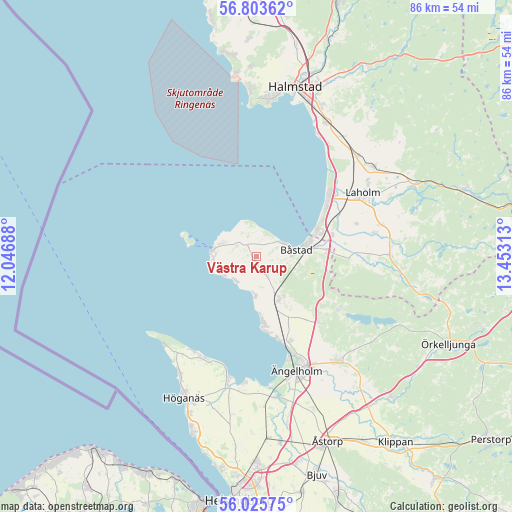
Västra Karup GPS coordinates[2]
56° 25' 0.012" North, 12° 45' 0" East
| Map corner | latitude | longitude |
|---|---|---|
| Upper-left | 56.80362°, | 12.04688° |
| Center: | 56.41667°, | 12.75° |
| Lower-right: | 56.02575°, | 13.45313° |
| Map W x H: | 86.5×86.5 km | = 53.7×53.7mi |
| max Lat: | 67.85572° ⇑84.9% North |
| Västra Karup: | 56.41667° |
| min Lat: | ⇓15.1% South 55.34337° |
| min Long | Västra Karup | max Long |
| 11.1712° | 12.75° | 24.13676° |
| W 14.6%⇐ | ⇒85.4% E |
Elevation
Elevation of Västra Karup is 120 m = 394 ft, and this is 37.4 m = 123 ft above average elevation for this country.
| Max E: |
663 m = 2175 ft | 24.9% |
| Västra Karup | 120 m 394 ft | |
| Avg. | 82.6 m = 271 ft | |
Min E: |
-1 m = -3 ft | 75.1% |
See also: Sweden elevation on elevation.city.
Geographical zone
Västra Karup is located in North temperate zone (between Tropic of Cancer and the Arctic Circle). Distance of this North polar circle is 1128.2 km =701 mi to North.| Distance of | km | miles | from Västra Karup |
|---|---|---|---|
| North Pole | 3734.1 | 2320.3 | to North |
| Arctic Circle | 1128.2 | 701 | to North |
| Tropic Cancer | 3667 | 2278.6 | to South |
| Equator | 6272.9 | 3897.8 | to South |


Nearby cities:
15 places around Västra Karup: (largest is in red/bold)
• Arild
19.1 km =11.9 mi,  214°
214°
• Båstad
6.5 km =4 mi,  79°
79°
• Förslöv
8.5 km =5.3 mi,  151°
151°
• Grevie
3.5 km =2.2 mi,  143°
143°
• Grevie
6.4 km =4 mi, 151°
• Hjärnarp
15.1 km =9.4 mi, 137°
• Laholm
20.9 km =13 mi,  59°
59°
• Mellbystrand
13.9 km =8.6 mi, 56°
• Skepparkroken
14.2 km =8.8 mi,  167°
167°
• Skottorp
13.4 km =8.3 mi,  74°
74°
• Torekov
7.2 km =4.5 mi,  277°
277°
• Vallberga
17.3 km =10.7 mi, 71°
• Vejbystrand
11 km =6.8 mi, 174°
• Ängelholm
20.5 km =12.7 mi,  160°
160°
• Östra Karup
11.5 km =7.1 mi, 84°
Sources, notices
• [Note1] Compared only with cities in Sweden existing in our database
• [Src1] Map data: © OpenStreetMap contributors (CC-BY-SA)
• [Src2] Other city data from geonames.org with taken over terms of usage.
• [Src3] Geographical zone / Annual Mean Temperature by Robert A. Rohde @ Wikipedia
