Laholm geodata
Laholm (Halland) is a seat of a second-order administrative division; located in Sweden in Europe/Stockholm (GMT+2) time zone. With population of 6,527 people, there are 218 cities with bigger population in this country. Compared to other cities in Sweden, 83.9% of cities are located further ↑North; 78.9% of cities are located further →East and 78.5% of cities have higher elevation than Laholm. Note1


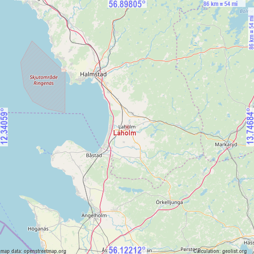
Laholm GPS coordinates[2]
56° 30' 43.452" North, 13° 2' 37.356" East
| Map corner | latitude | longitude |
|---|---|---|
| Upper-left | 56.89805°, | 12.34059° |
| Center: | 56.51207°, | 13.04371° |
| Lower-right: | 56.12212°, | 13.74684° |
| Map W x H: | 86.3×86.3 km | = 53.6×53.6mi |
| max Lat: | 67.85572° ⇑83.9% North |
| Laholm: | 56.51207° |
| min Lat: | ⇓16.1% South 55.34337° |
| min Long | Laholm | max Long |
| 11.1712° | 13.04371° | 24.13676° |
| W 21.1%⇐ | ⇒78.9% E |
Elevation
Elevation of Laholm is 17 m = 56 ft, and this is 65.6 m = 215 ft below average elevation for this country.
| Max E: |
663 m = 2175 ft | 78.5% |
| Avg. | 82.6 m = 271 ft | |
| Laholm | 17 m = 56 ft | |
Min E: |
-1 m = -3 ft | 21.5% |
See also: Sweden elevation on elevation.city.
Geographical zone
Laholm is located in North temperate zone (between Tropic of Cancer and the Arctic Circle). Distance of this North polar circle is 1117.6 km =694.4 mi to North.| Distance of | km | miles | from Laholm |
|---|---|---|---|
| North Pole | 3723.5 | 2313.7 | to North |
| Arctic Circle | 1117.6 | 694.4 | to North |
| Tropic Cancer | 3677.6 | 2285.2 | to South |
| Equator | 6283.6 | 3904.4 | to South |


Nearby cities:
15 places around Laholm: (largest is in red/bold)
• Båstad
15 km =9.3 mi,  230°
230°
• Eldsberga
10.1 km =6.3 mi,  344°
344°
• Fyllinge
17.2 km =10.7 mi,  333°
333°
• Genevad
6.3 km =3.9 mi,  353°
353°
• Gullbranna
10.6 km =6.6 mi, 327°
• Knäred
17.2 km =10.7 mi,  87°
87°
• Kyrkhult
14.3 km =8.9 mi,  72°
72°
• Lilla Tjärby
1.8 km =1.1 mi,  25°
25°
• Mellbystrand
7 km =4.3 mi,  245°
245°
• Skottorp
8.6 km =5.3 mi,  216°
216°
• Trönninge
13.5 km =8.4 mi, 329°
• Vallberga
5.3 km =3.3 mi,  198°
198°
• Veinge
4.4 km =2.7 mi,  18°
18°
• Våxtorp
11.6 km =7.2 mi,  156°
156°
• Östra Karup
11.6 km =7.2 mi,  214°
214°
Sources, notices
• [Note1] Compared only with cities in Sweden existing in our database
• [Src1] Map data: © OpenStreetMap contributors (CC-BY-SA)
• [Src2] Other city data from geonames.org with taken over terms of usage.
• [Src3] Geographical zone / Annual Mean Temperature by Robert A. Rohde @ Wikipedia
