Vallberga geodata
Vallberga (Halland) is a populated place; located in Sweden in Europe/Stockholm (GMT+2) time zone. With population of 655 people, there are 1114 cities with bigger population in this country. Compared to other cities in Sweden, 84.3% of cities are located further ↑North; 79.5% of cities are located further →East and 84.8% of cities have higher elevation than Vallberga. Note1


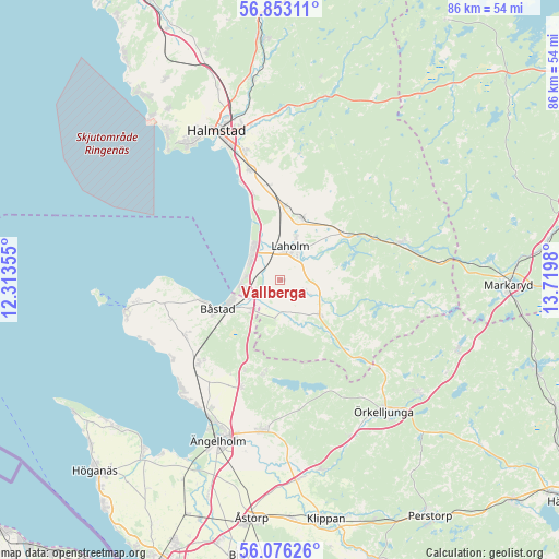
Vallberga GPS coordinates[2]
56° 28' 0.012" North, 13° 1' 0.012" East
| Map corner | latitude | longitude |
|---|---|---|
| Upper-left | 56.85311°, | 12.31355° |
| Center: | 56.46667°, | 13.01667° |
| Lower-right: | 56.07626°, | 13.7198° |
| Map W x H: | 86.4×86.4 km | = 53.7×53.7mi |
| max Lat: | 67.85572° ⇑84.3% North |
| Vallberga: | 56.46667° |
| min Lat: | ⇓15.7% South 55.34337° |
| min Long | Vallberga | max Long |
| 11.1712° | 13.01667° | 24.13676° |
| W 20.5%⇐ | ⇒79.5% E |
Elevation
Elevation of Vallberga is 13 m = 43 ft, and this is 69.6 m = 228 ft below average elevation for this country.
| Max E: |
663 m = 2175 ft | 84.8% |
| Avg. | 82.6 m = 271 ft | |
| Vallberga | 13 m = 43 ft | |
Min E: |
-1 m = -3 ft | 15.2% |
See also: Sweden elevation on elevation.city.
Geographical zone
Vallberga is located in North temperate zone (between Tropic of Cancer and the Arctic Circle). Distance of this North polar circle is 1122.7 km =697.6 mi to North.| Distance of | km | miles | from Vallberga |
|---|---|---|---|
| North Pole | 3728.6 | 2316.8 | to North |
| Arctic Circle | 1122.7 | 697.6 | to North |
| Tropic Cancer | 3672.6 | 2282 | to South |
| Equator | 6278.5 | 3901.3 | to South |


Nearby cities:
15 places around Vallberga: (largest is in red/bold)
• Båstad
11 km =6.8 mi,  246°
246°
• Eldsberga
14.9 km =9.3 mi,  356°
356°
• Genevad
11.4 km =7.1 mi,  4°
4°
• Grevie
16.6 km =10.3 mi,  239°
239°
• Grevie
17.4 km =10.8 mi,  230°
230°
• Gullbranna
14.5 km =9 mi,  343°
343°
• Laholm
5.3 km =3.3 mi,  18°
18°
• Lilla Tjärby
7.1 km =4.4 mi, 20°
• Mellbystrand
5.2 km =3.2 mi,  293°
293°
• Skottorp
3.9 km =2.4 mi, 240°
• Trönninge
17.4 km =10.8 mi, 342°
• Veinge
9.8 km =6.1 mi, 18°
• Västra Karup
17.3 km =10.7 mi, 251°
• Våxtorp
8.4 km =5.2 mi,  131°
131°
• Östra Karup
6.7 km =4.2 mi, 227°
Sources, notices
• [Note1] Compared only with cities in Sweden existing in our database
• [Src1] Map data: © OpenStreetMap contributors (CC-BY-SA)
• [Src2] Other city data from geonames.org with taken over terms of usage.
• [Src3] Geographical zone / Annual Mean Temperature by Robert A. Rohde @ Wikipedia
