Kungsängen geodata
Kungsängen (Stockholm) is a seat of a second-order administrative division; located in Sweden in Europe/Stockholm (GMT+2) time zone. With population of 10,151 people, there are 150 cities with bigger population in this country. Compared to other cities in Sweden, 65.8% of cities are located further ↓South; 82.1% of cities are located further ←West and 57.4% of cities have higher elevation than Kungsängen. Note1


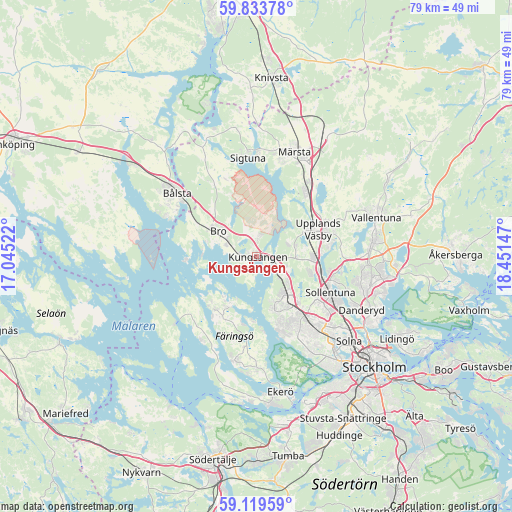
Kungsängen GPS coordinates[2]
59° 28' 42.852" North, 17° 44' 54.024" East
| Map corner | latitude | longitude |
|---|---|---|
| Upper-left | 59.83378°, | 17.04522° |
| Center: | 59.47857°, | 17.74834° |
| Lower-right: | 59.11959°, | 18.45147° |
| Map W x H: | 79.4×79.4 km | = 49.3×49.3mi |
| max Lat: | 67.85572° ⇑34.2% North |
| Kungsängen: | 59.47857° |
| min Lat: | ⇓65.8% South 55.34337° |
| min Long | Kungsängen | max Long |
| 11.1712° | 17.74834° | 24.13676° |
| W 82.1%⇐ | ⇒17.9% E |
Elevation
Elevation of Kungsängen is 39 m = 128 ft, and this is 43.6 m = 143 ft below average elevation for this country.
| Max E: |
663 m = 2175 ft | 57.4% |
| Avg. | 82.6 m = 271 ft | |
| Kungsängen | 39 m = 128 ft | |
Min E: |
-1 m = -3 ft | 42.6% |
See also: Sweden elevation on elevation.city.
Geographical zone
Kungsängen is located in North temperate zone (between Tropic of Cancer and the Arctic Circle). Distance of this North polar circle is 787.8 km =489.5 mi to North.| Distance of | km | miles | from Kungsängen |
|---|---|---|---|
| North Pole | 3393.7 | 2108.7 | to North |
| Arctic Circle | 787.8 | 489.5 | to North |
| Tropic Cancer | 4007.5 | 2490.1 | to South |
| Equator | 6613.4 | 4109.4 | to South |


Nearby cities:
15 places around Kungsängen: (largest is in red/bold)
• Akalla
11.8 km =7.3 mi,  127°
127°
• Bro
7.8 km =4.8 mi,  303°
303°
• Brunna
4.2 km =2.6 mi,  1°
1°
• Jakobsberg
7.9 km =4.9 mi,  141°
141°
• Kista
13.9 km =8.6 mi, 127°
• Kungsberga
10.6 km =6.6 mi,  219°
219°
• Rosersberg
13.9 km =8.6 mi,  33°
33°
• Råby
15.3 km =9.5 mi,  293°
293°
• Sigtuna
15.5 km =9.6 mi,  354°
354°
• Sollentuna
12.8 km =8 mi,  116°
116°
• Steninge
14.1 km =8.8 mi,  13°
13°
• Sylta
1.8 km =1.1 mi,  275°
275°
• Tensta
12.8 km =8 mi, 137°
• Upplands Väsby
10.2 km =6.3 mi,  64°
64°
• Ölsta
10.4 km =6.5 mi,  212°
212°
Sources, notices
• [Note1] Compared only with cities in Sweden existing in our database
• [Src1] Map data: © OpenStreetMap contributors (CC-BY-SA)
• [Src2] Other city data from geonames.org with taken over terms of usage.
• [Src3] Geographical zone / Annual Mean Temperature by Robert A. Rohde @ Wikipedia
