Björnlunda geodata
Björnlunda (Södermanland) is a populated place; located in Sweden in Europe/Stockholm (GMT+2) time zone. With population of 838 people, there are 937 cities with bigger population in this country. Compared to other cities in Sweden, 54.7% of cities are located further ↓South; 76% of cities are located further ←West and 67.8% of cities have higher elevation than Björnlunda. Note1
Administrative division(s):
- Level 1: Södermanland
- Level 2: Gnesta Kommun
- Level 3: Daga
- Level 4: Björnlunda socken


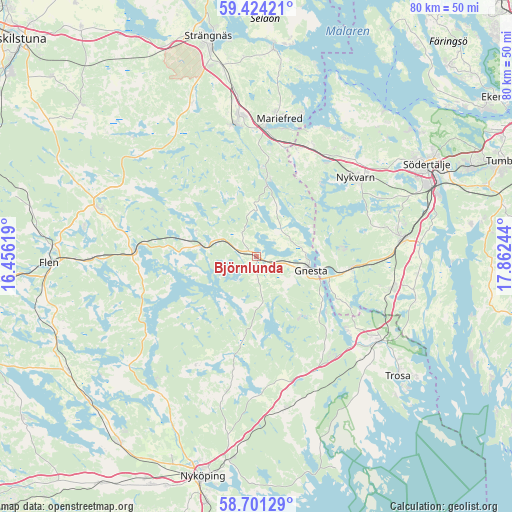
Björnlunda GPS coordinates[2]
59° 3' 52.74" North, 17° 9' 33.516" East
| Map corner | latitude | longitude |
|---|---|---|
| Upper-left | 59.42421°, | 16.45619° |
| Center: | 59.06465°, | 17.15931° |
| Lower-right: | 58.70129°, | 17.86244° |
| Map W x H: | 80.4×80.4 km | = 50×50mi |
| max Lat: | 67.85572° ⇑45.3% North |
| Björnlunda: | 59.06465° |
| min Lat: | ⇓54.7% South 55.34337° |
| min Long | Björnlunda | max Long |
| 11.1712° | 17.15931° | 24.13676° |
| W 76%⇐ | ⇒24% E |
Elevation
Elevation of Björnlunda is 27 m = 89 ft, and this is 55.6 m = 182 ft below average elevation for this country.
| Max E: |
663 m = 2175 ft | 67.8% |
| Avg. | 82.6 m = 271 ft | |
| Björnlunda | 27 m = 89 ft | |
Min E: |
-1 m = -3 ft | 32.2% |
See also: Sweden elevation on elevation.city.
Geographical zone
Björnlunda is located in North temperate zone (between Tropic of Cancer and the Arctic Circle). Distance of this North polar circle is 833.8 km =518.1 mi to North.| Distance of | km | miles | from Björnlunda |
|---|---|---|---|
| North Pole | 3439.7 | 2137.3 | to North |
| Arctic Circle | 833.8 | 518.1 | to North |
| Tropic Cancer | 3961.5 | 2461.6 | to South |
| Equator | 6567.4 | 4080.8 | to South |


Nearby cities:
15 places around Björnlunda: (largest is in red/bold)
• Ekeby
29.1 km =18.1 mi,  44°
44°
• Gnesta
8.9 km =5.5 mi,  102°
102°
• Hölö
22 km =13.7 mi, 104°
• Järna
23.4 km =14.5 mi,  82°
82°
• Malmköping
25.5 km =15.8 mi,  287°
287°
• Mariefred
22 km =13.7 mi,  9°
9°
• Marielund
20.8 km =12.9 mi,  3°
3°
• Mölnbo
14.8 km =9.2 mi, 96°
• Nykvarn
20 km =12.4 mi,  51°
51°
• Sparreholm
19.6 km =12.2 mi,  270°
270°
• Stjärnhov
9.3 km =5.8 mi,  282°
282°
• Trosa
29.1 km =18.1 mi,  130°
130°
• Tystberga
24.2 km =15 mi,  169°
169°
• Vagnhärad
23 km =14.3 mi, 125°
• Åkers Styckebruk
21.1 km =13.1 mi,  348°
348°
Sources, notices
• [Note1] Compared only with cities in Sweden existing in our database
• [Src1] Map data: © OpenStreetMap contributors (CC-BY-SA)
• [Src2] Other city data from geonames.org with taken over terms of usage.
• [Src3] Geographical zone / Annual Mean Temperature by Robert A. Rohde @ Wikipedia
