Tibro geodata
Tibro (Västra Götaland) is a seat of a second-order administrative division; located in Sweden in Europe/Stockholm (GMT+2) time zone. With population of 8,396 people, there are 175 cities with bigger population in this country. Compared to other cities in Sweden, 54% of cities are located further ↑North; 61.6% of cities are located further →East and 74.5% of cities have lower elevation than Tibro. Note1


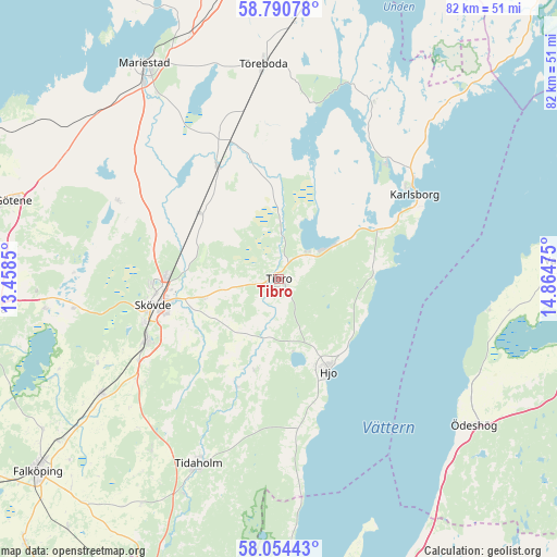
Tibro GPS coordinates[2]
58° 25' 28.308" North, 14° 9' 41.832" East
| Map corner | latitude | longitude |
|---|---|---|
| Upper-left | 58.79078°, | 13.4585° |
| Center: | 58.42453°, | 14.16162° |
| Lower-right: | 58.05443°, | 14.86475° |
| Map W x H: | 81.9×81.9 km | = 50.9×50.9mi |
| max Lat: | 67.85572° ⇑54% North |
| Tibro: | 58.42453° |
| min Lat: | ⇓46% South 55.34337° |
| min Long | Tibro | max Long |
| 11.1712° | 14.16162° | 24.13676° |
| W 38.4%⇐ | ⇒61.6% E |
Elevation
Elevation of Tibro is 117 m = 384 ft, and this is 34.4 m = 113 ft above average elevation for this country.
| Max E: |
663 m = 2175 ft | 25.5% |
| Tibro | 117 m 384 ft | |
| Avg. | 82.6 m = 271 ft | |
Min E: |
-1 m = -3 ft | 74.5% |
See also: Sweden elevation on elevation.city.
Geographical zone
Tibro is located in North temperate zone (between Tropic of Cancer and the Arctic Circle). Distance of this North polar circle is 905 km =562.3 mi to North.| Distance of | km | miles | from Tibro |
|---|---|---|---|
| North Pole | 3510.9 | 2181.6 | to North |
| Arctic Circle | 905 | 562.3 | to North |
| Tropic Cancer | 3890.3 | 2417.3 | to South |
| Equator | 6496.2 | 4036.6 | to South |


Nearby cities:
15 places around Tibro: (largest is in red/bold)
• Fagersanna
9.3 km =5.8 mi,  59°
59°
• Hjo
15.6 km =9.7 mi,  151°
151°
• Igelstorp
11.7 km =7.3 mi,  256°
256°
• Karlsborg
23.6 km =14.7 mi, 57°
• Lerdala
26.8 km =16.7 mi,  282°
282°
• Moholm
21.4 km =13.3 mi,  340°
340°
• Mölltorp
16.2 km =10.1 mi, 58°
• Olofstorp
21.6 km =13.4 mi,  205°
205°
• Skultorp
20.9 km =13 mi,  246°
246°
• Skövde
18.8 km =11.7 mi, 258°
• Stöpen
18.2 km =11.3 mi,  289°
289°
• Tidan
19 km =11.8 mi,  331°
331°
• Timmersdala
26.8 km =16.7 mi,  296°
296°
• Väring
14.3 km =8.9 mi,  308°
308°
• Värsås
10.5 km =6.5 mi,  218°
218°
Sources, notices
• [Note1] Compared only with cities in Sweden existing in our database
• [Src1] Map data: © OpenStreetMap contributors (CC-BY-SA)
• [Src2] Other city data from geonames.org with taken over terms of usage.
• [Src3] Geographical zone / Annual Mean Temperature by Robert A. Rohde @ Wikipedia
