Fagersanna geodata
Fagersanna (Västra Götaland) is a populated place; located in Sweden in Europe/Stockholm (GMT+2) time zone. With population of 684 people, there are 1085 cities with bigger population in this country. Compared to other cities in Sweden, 53.5% of cities are located further ↑North; 59.2% of cities are located further →East and 74.1% of cities have lower elevation than Fagersanna. Note1


Fagersanna GPS coordinates[2]
58° 28' 0.012" North, 14° 18' 0" East
| Map corner | latitude | longitude |
|---|---|---|
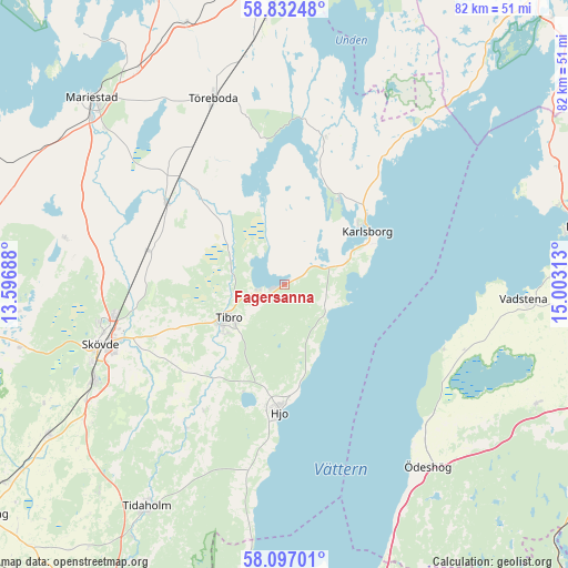
| Upper-left | 58.83248°, | 13.59688° |
| Center: | 58.46667°, | 14.3° |
| Lower-right: | 58.09701°, | 15.00313° |
| Map W x H: | 81.8×81.8 km | = 50.8×50.8mi |
| max Lat: | 67.85572° ⇑53.5% North |
| Fagersanna: | 58.46667° |
| min Lat: | ⇓46.5% South 55.34337° |
| min Long | Fagersanna | max Long |
| 11.1712° | 14.3° | 24.13676° |
| W 40.8%⇐ | ⇒59.2% E |
Elevation
Elevation of Fagersanna is 115 m = 377 ft, and this is 32.4 m = 106 ft above average elevation for this country.
| Max E: |
663 m = 2175 ft | 25.9% |
| Fagersanna | 115 m 377 ft | |
| Avg. | 82.6 m = 271 ft | |
Min E: |
-1 m = -3 ft | 74.1% |
See also: Sweden elevation on elevation.city.
Geographical zone
Fagersanna is located in North temperate zone (between Tropic of Cancer and the Arctic Circle). Distance of this North polar circle is 900.3 km =559.4 mi to North.| Distance of | km | miles | from Fagersanna |
|---|---|---|---|
| North Pole | 3506.2 | 2178.7 | to North |
| Arctic Circle | 900.3 | 559.4 | to North |
| Tropic Cancer | 3895 | 2420.2 | to South |
| Equator | 6500.9 | 4039.5 | to South |


Nearby cities:
15 places around Fagersanna: (largest is in red/bold)
• Herrestad
30.5 km =19 mi,  107°
107°
• Hjo
18.4 km =11.4 mi,  182°
182°
• Igelstorp
20.8 km =12.9 mi,  249°
249°
• Karlsborg
14.2 km =8.8 mi,  56°
56°
• Moholm
21.7 km =13.5 mi,  315°
315°
• Mölltorp
6.9 km =4.3 mi, 57°
• Olofstorp
29.8 km =18.5 mi,  215°
215°
• Skultorp
30.1 km =18.7 mi,  244°
244°
• Skövde
27.8 km =17.3 mi, 252°
• Stöpen
25.3 km =15.7 mi,  272°
272°
• Tibro
9.3 km =5.8 mi, 239°
• Tidan
20.9 km =13 mi,  305°
305°
• Töreboda
28.6 km =17.8 mi,  339°
339°
• Väring
19.7 km =12.2 mi,  282°
282°
• Värsås
19.5 km =12.1 mi,  228°
228°
Sources, notices
• [Note1] Compared only with cities in Sweden existing in our database
• [Src1] Map data: © OpenStreetMap contributors (CC-BY-SA)
• [Src2] Other city data from geonames.org with taken over terms of usage.
• [Src3] Geographical zone / Annual Mean Temperature by Robert A. Rohde @ Wikipedia
