Karlsborg geodata
Karlsborg (Västra Götaland) is a seat of a second-order administrative division; located in Sweden in Europe/Stockholm (GMT+2) time zone. With population of 3,624 people, there are 353 cities with bigger population in this country. Compared to other cities in Sweden, 51.9% of cities are located further ↑North; 56.9% of cities are located further →East and 68% of cities have lower elevation than Karlsborg. Note1


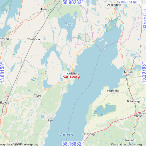
Karlsborg GPS coordinates[2]
58° 32' 14.064" North, 14° 30' 16.92" East
| Map corner | latitude | longitude |
|---|---|---|
| Upper-left | 58.90232°, | 13.80158° |
| Center: | 58.53724°, | 14.5047° |
| Lower-right: | 58.16832°, | 15.20783° |
| Map W x H: | 81.6×81.6 km | = 50.7×50.7mi |
| max Lat: | 67.85572° ⇑51.9% North |
| Karlsborg: | 58.53724° |
| min Lat: | ⇓48.1% South 55.34337° |
| min Long | Karlsborg | max Long |
| 11.1712° | 14.5047° | 24.13676° |
| W 43.1%⇐ | ⇒56.9% E |
Elevation
Elevation of Karlsborg is 93 m = 305 ft, and this is 10.4 m = 34 ft above average elevation for this country.
| Max E: |
663 m = 2175 ft | 32% |
| Karlsborg | 93 m 305 ft | |
| Avg. | 82.6 m = 271 ft | |
Min E: |
-1 m = -3 ft | 68% |
See also: Sweden elevation on elevation.city.
Geographical zone
Karlsborg is located in North temperate zone (between Tropic of Cancer and the Arctic Circle). Distance of this North polar circle is 892.4 km =554.5 mi to North.| Distance of | km | miles | from Karlsborg |
|---|---|---|---|
| North Pole | 3498.3 | 2173.7 | to North |
| Arctic Circle | 892.4 | 554.5 | to North |
| Tropic Cancer | 3902.8 | 2425.1 | to South |
| Equator | 6508.7 | 4044.3 | to South |


Nearby cities:
15 places around Karlsborg: (largest is in red/bold)
• Fagersanna
14.2 km =8.8 mi,  236°
236°
• Herrestad
24.2 km =15 mi,  134°
134°
• Hjo
29.1 km =18.1 mi,  205°
205°
• Igelstorp
34.8 km =21.6 mi, 243°
• Moholm
28.1 km =17.5 mi,  285°
285°
• Motala
30.9 km =19.2 mi,  90°
90°
• Mölltorp
7.4 km =4.6 mi, 235°
• Stenstorp
33.2 km =20.6 mi,  100°
100°
• Tibro
23.6 km =14.7 mi, 237°
• Tidan
29.3 km =18.2 mi,  278°
278°
• Töreboda
29 km =18 mi,  310°
310°
• Vadstena
24.4 km =15.2 mi,  113°
113°
• Väderstad
34.3 km =21.3 mi,  135°
135°
• Väring
31.3 km =19.4 mi,  263°
263°
• Värsås
33.7 km =20.9 mi,  231°
231°
Sources, notices
• [Note1] Compared only with cities in Sweden existing in our database
• [Src1] Map data: © OpenStreetMap contributors (CC-BY-SA)
• [Src2] Other city data from geonames.org with taken over terms of usage.
• [Src3] Geographical zone / Annual Mean Temperature by Robert A. Rohde @ Wikipedia
