Hofors geodata
Hofors (Gävleborg) is a seat of a second-order administrative division; located in Sweden in Europe/Stockholm (GMT+2) time zone. With population of 6,090 people, there are 230 cities with bigger population in this country. Compared to other cities in Sweden, 79.1% of cities are located further ↓South; 65.2% of cities are located further ←West and 74% of cities have lower elevation than Hofors. Note1


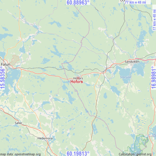
Hofors GPS coordinates[2]
60° 32' 44.628" North, 16° 17' 12.048" East
| Map corner | latitude | longitude |
|---|---|---|
| Upper-left | 60.88963°, | 15.58356° |
| Center: | 60.54573°, | 16.28668° |
| Lower-right: | 60.19813°, | 16.98981° |
| Map W x H: | 76.9×76.9 km | = 47.8×47.8mi |
| max Lat: | 67.85572° ⇑20.9% North |
| Hofors: | 60.54573° |
| min Lat: | ⇓79.1% South 55.34337° |
| min Long | Hofors | max Long |
| 11.1712° | 16.28668° | 24.13676° |
| W 65.2%⇐ | ⇒34.8% E |
Elevation
Elevation of Hofors is 114 m = 374 ft, and this is 31.4 m = 103 ft above average elevation for this country.
| Max E: |
663 m = 2175 ft | 26% |
| Hofors | 114 m 374 ft | |
| Avg. | 82.6 m = 271 ft | |
Min E: |
-1 m = -3 ft | 74% |
See also: Sweden elevation on elevation.city.
Geographical zone
Hofors is located in North temperate zone (between Tropic of Cancer and the Arctic Circle). Distance of this North polar circle is 669.1 km =415.8 mi to North.| Distance of | km | miles | from Hofors |
|---|---|---|---|
| North Pole | 3275 | 2035 | to North |
| Arctic Circle | 669.1 | 415.8 | to North |
| Tropic Cancer | 4126.1 | 2563.8 | to South |
| Equator | 6732.1 | 4183.1 | to South |


Nearby cities:
15 places around Hofors: (largest is in red/bold)
• Bengtsheden
29.1 km =18.1 mi,  309°
309°
• Garpenberg
25.9 km =16.1 mi,  190°
190°
• Hammarby
15.5 km =9.6 mi,  90°
90°
• Horndal
28.2 km =17.5 mi,  165°
165°
• Järbo
25.6 km =15.9 mi,  41°
41°
• Kungsgården
19 km =11.8 mi,  71°
71°
• Långshyttan
17.1 km =10.6 mi,  232°
232°
• Sandviken
27.4 km =17 mi, 73°
• Storvik
14.1 km =8.8 mi, 72°
• Sundborn
30.7 km =19.1 mi,  292°
292°
• Svärdsjö
30.1 km =18.7 mi,  315°
315°
• Torsåker
10.8 km =6.7 mi,  111°
111°
• Vika
31.4 km =19.5 mi,  263°
263°
• Årsunda
24.7 km =15.3 mi,  97°
97°
• Åshammar
18.1 km =11.2 mi,  55°
55°
Sources, notices
• [Note1] Compared only with cities in Sweden existing in our database
• [Src1] Map data: © OpenStreetMap contributors (CC-BY-SA)
• [Src2] Other city data from geonames.org with taken over terms of usage.
• [Src3] Geographical zone / Annual Mean Temperature by Robert A. Rohde @ Wikipedia
