Tillberga geodata
Tillberga (Västmanland) is a populated place; located in Sweden in Europe/Stockholm (GMT+2) time zone. With population of 2,151 people, there are 500 cities with bigger population in this country. Compared to other cities in Sweden, 69.6% of cities are located further ↓South; 70.4% of cities are located further ←West and 58.8% of cities have higher elevation than Tillberga. Note1


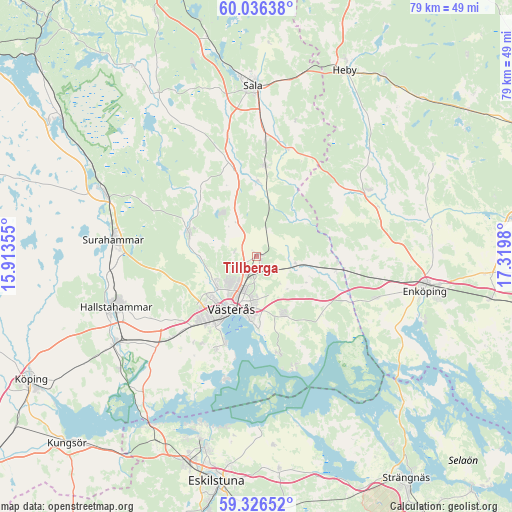
Tillberga GPS coordinates[2]
59° 40' 59.988" North, 16° 37' 0.012" East
| Map corner | latitude | longitude |
|---|---|---|
| Upper-left | 60.03638°, | 15.91355° |
| Center: | 59.68333°, | 16.61667° |
| Lower-right: | 59.32652°, | 17.3198° |
| Map W x H: | 78.9×78.9 km | = 49×49mi |
| max Lat: | 67.85572° ⇑30.4% North |
| Tillberga: | 59.68333° |
| min Lat: | ⇓69.6% South 55.34337° |
| min Long | Tillberga | max Long |
| 11.1712° | 16.61667° | 24.13676° |
| W 70.4%⇐ | ⇒29.6% E |
Elevation
Elevation of Tillberga is 37 m = 121 ft, and this is 45.6 m = 150 ft below average elevation for this country.
| Max E: |
663 m = 2175 ft | 58.8% |
| Avg. | 82.6 m = 271 ft | |
| Tillberga | 37 m = 121 ft | |
Min E: |
-1 m = -3 ft | 41.2% |
See also: Sweden elevation on elevation.city.
Geographical zone
Tillberga is located in North temperate zone (between Tropic of Cancer and the Arctic Circle). Distance of this North polar circle is 765 km =475.3 mi to North.| Distance of | km | miles | from Tillberga |
|---|---|---|---|
| North Pole | 3370.9 | 2094.6 | to North |
| Arctic Circle | 765 | 475.3 | to North |
| Tropic Cancer | 4030.2 | 2504.2 | to South |
| Equator | 6636.2 | 4123.5 | to South |


Nearby cities:
15 places around Tillberga: (largest is in red/bold)
• Barkarö
16.1 km =10 mi,  202°
202°
• Dingtuna
17.8 km =11.1 mi,  226°
226°
• Enhagen-Ekbacken
14 km =8.7 mi, 200°
• Fjärdhundra
19.9 km =12.4 mi,  58°
58°
• Hallstahammar
23.1 km =14.4 mi,  250°
250°
• Hummelsta
19.4 km =12.1 mi,  108°
108°
• Hökåsen
2.6 km =1.6 mi, 225°
• Irsta
10.4 km =6.5 mi,  153°
153°
• Irsta
17.9 km =11.1 mi,  84°
84°
• Kolbäck
25.4 km =15.8 mi,  238°
238°
• Ramnäs
25.1 km =15.6 mi,  291°
291°
• Ransta
14.2 km =8.8 mi,  4°
4°
• Skultuna
11.8 km =7.3 mi, 288°
• Surahammar
22.3 km =13.9 mi,  276°
276°
• Västerås
8.3 km =5.2 mi,  205°
205°
Sources, notices
• [Note1] Compared only with cities in Sweden existing in our database
• [Src1] Map data: © OpenStreetMap contributors (CC-BY-SA)
• [Src2] Other city data from geonames.org with taken over terms of usage.
• [Src3] Geographical zone / Annual Mean Temperature by Robert A. Rohde @ Wikipedia
