Stallarholmen geodata
Stallarholmen (Södermanland) is a populated place; located in Sweden in Europe/Stockholm (GMT+2) time zone. With population of 1,671 people, there are 604 cities with bigger population in this country. Compared to other cities in Sweden, 62.6% of cities are located further ↓South; 76.3% of cities are located further ←West and 97.4% of cities have higher elevation than Stallarholmen. Note1


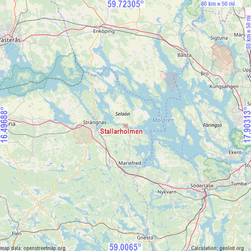
Stallarholmen GPS coordinates[2]
59° 22' 0.012" North, 17° 12' 0" East
| Map corner | latitude | longitude |
|---|---|---|
| Upper-left | 59.72305°, | 16.49688° |
| Center: | 59.36667°, | 17.2° |
| Lower-right: | 59.0065°, | 17.90313° |
| Map W x H: | 79.7×79.7 km | = 49.5×49.5mi |
| max Lat: | 67.85572° ⇑37.4% North |
| Stallarholmen: | 59.36667° |
| min Lat: | ⇓62.6% South 55.34337° |
| min Long | Stallarholmen | max Long |
| 11.1712° | 17.2° | 24.13676° |
| W 76.3%⇐ | ⇒23.7% E |
Elevation
Elevation of Stallarholmen is 3 m = 10 ft, and this is 79.6 m = 261 ft below average elevation for this country.
| Max E: |
663 m = 2175 ft | 97.4% |
| Avg. | 82.6 m = 271 ft | |
| Stallarholmen | 3 m = 10 ft | |
Min E: |
-1 m = -3 ft | 2.6% |
See also: Sweden elevation on elevation.city.
Geographical zone
Stallarholmen is located in North temperate zone (between Tropic of Cancer and the Arctic Circle). Distance of this North polar circle is 800.2 km =497.2 mi to North.| Distance of | km | miles | from Stallarholmen |
|---|---|---|---|
| North Pole | 3406.1 | 2116.5 | to North |
| Arctic Circle | 800.2 | 497.2 | to North |
| Tropic Cancer | 3995 | 2482.4 | to South |
| Equator | 6601 | 4101.7 | to South |


Nearby cities:
15 places around Stallarholmen: (largest is in red/bold)
• Bredsand
25.2 km =15.7 mi,  342°
342°
• Bålsta
29 km =18 mi,  39°
39°
• Ekeby
22.3 km =13.9 mi,  125°
125°
• Grillby
29 km =18 mi,  6°
6°
• Härad
16.8 km =10.4 mi,  267°
267°
• Kungsberga
24.7 km =15.3 mi,  80°
80°
• Mariefred
12 km =7.5 mi,  173°
173°
• Marielund
12.9 km =8 mi,  184°
184°
• Nykvarn
24.9 km =15.5 mi,  147°
147°
• Råby
25.1 km =15.6 mi, 42°
• Stenhamra
27.9 km =17.3 mi,  97°
97°
• Strängnäs
9.6 km =6 mi,  277°
277°
• Viksäter
27.4 km =17 mi,  120°
120°
• Åkers Styckebruk
14.6 km =9.1 mi,  207°
207°
• Ölsta
25.8 km =16 mi, 81°
Sources, notices
• [Note1] Compared only with cities in Sweden existing in our database
• [Src1] Map data: © OpenStreetMap contributors (CC-BY-SA)
• [Src2] Other city data from geonames.org with taken over terms of usage.
• [Src3] Geographical zone / Annual Mean Temperature by Robert A. Rohde @ Wikipedia
