Strängnäs geodata
Strängnäs (Södermanland) is a seat of a second-order administrative division; located in Sweden in Europe/Stockholm (GMT+2) time zone. With population of 13,693 people, there are 113 cities with bigger population in this country. Compared to other cities in Sweden, 62.8% of cities are located further ↓South; 74% of cities are located further ←West and 82.7% of cities have higher elevation than Strängnäs. Note1


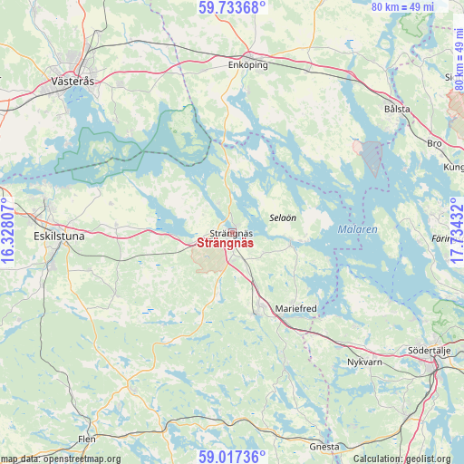
Strängnäs GPS coordinates[2]
59° 22' 38.676" North, 17° 1' 52.284" East
| Map corner | latitude | longitude |
|---|---|---|
| Upper-left | 59.73368°, | 16.32807° |
| Center: | 59.37741°, | 17.03119° |
| Lower-right: | 59.01736°, | 17.73432° |
| Map W x H: | 79.6×79.6 km | = 49.5×49.5mi |
| max Lat: | 67.85572° ⇑37.2% North |
| Strängnäs: | 59.37741° |
| min Lat: | ⇓62.8% South 55.34337° |
| min Long | Strängnäs | max Long |
| 11.1712° | 17.03119° | 24.13676° |
| W 74%⇐ | ⇒26% E |
Elevation
Elevation of Strängnäs is 14 m = 46 ft, and this is 68.6 m = 225 ft below average elevation for this country.
| Max E: |
663 m = 2175 ft | 82.7% |
| Avg. | 82.6 m = 271 ft | |
| Strängnäs | 14 m = 46 ft | |
Min E: |
-1 m = -3 ft | 17.3% |
See also: Sweden elevation on elevation.city.
Geographical zone
Strängnäs is located in North temperate zone (between Tropic of Cancer and the Arctic Circle). Distance of this North polar circle is 799 km =496.5 mi to North.| Distance of | km | miles | from Strängnäs |
|---|---|---|---|
| North Pole | 3404.9 | 2115.7 | to North |
| Arctic Circle | 799 | 496.5 | to North |
| Tropic Cancer | 3996.2 | 2483.1 | to South |
| Equator | 6602.1 | 4102.4 | to South |


Nearby cities:
15 places around Strängnäs: (largest is in red/bold)
• Bredsand
23 km =14.3 mi,  5°
5°
• Ekeby
31.1 km =19.3 mi,  117°
117°
• Enköping
28.9 km =18 mi, 5°
• Eskilstuna
29.7 km =18.5 mi,  267°
267°
• Grillby
30.5 km =19 mi,  24°
24°
• Hummelsta
28.2 km =17.5 mi,  349°
349°
• Hällberga
25.4 km =15.8 mi,  254°
254°
• Härad
7.5 km =4.7 mi,  255°
255°
• Irsta
31 km =19.3 mi,  322°
322°
• Kjulaås
20.7 km =12.9 mi, 271°
• Mariefred
17 km =10.6 mi,  140°
140°
• Marielund
16.5 km =10.3 mi,  148°
148°
• Stallarholmen
9.6 km =6 mi,  97°
97°
• Ärla
22.7 km =14.1 mi,  241°
241°
• Åkers Styckebruk
14.5 km =9 mi,  168°
168°
Sources, notices
• [Note1] Compared only with cities in Sweden existing in our database
• [Src1] Map data: © OpenStreetMap contributors (CC-BY-SA)
• [Src2] Other city data from geonames.org with taken over terms of usage.
• [Src3] Geographical zone / Annual Mean Temperature by Robert A. Rohde @ Wikipedia
