Härad geodata
Härad (Södermanland) is a populated place; located in Sweden in Europe/Stockholm (GMT+2) time zone. With population of 508 people, there are 1305 cities with bigger population in this country. Compared to other cities in Sweden, 62.3% of cities are located further ↓South; 72.7% of cities are located further ←West and 53% of cities have higher elevation than Härad. Note1


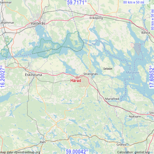
Härad GPS coordinates[2]
59° 21' 38.34" North, 16° 54' 12.204" East
| Map corner | latitude | longitude |
|---|---|---|
| Upper-left | 59.7171°, | 16.20027° |
| Center: | 59.36065°, | 16.90339° |
| Lower-right: | 59.00042°, | 17.60652° |
| Map W x H: | 79.7×79.7 km | = 49.5×49.5mi |
| max Lat: | 67.85572° ⇑37.7% North |
| Härad: | 59.36065° |
| min Lat: | ⇓62.3% South 55.34337° |
| min Long | Härad | max Long |
| 11.1712° | 16.90339° | 24.13676° |
| W 72.7%⇐ | ⇒27.3% E |
Elevation
Elevation of Härad is 45 m = 148 ft, and this is 37.6 m = 123 ft below average elevation for this country.
| Max E: |
663 m = 2175 ft | 53% |
| Avg. | 82.6 m = 271 ft | |
| Härad | 45 m = 148 ft | |
Min E: |
-1 m = -3 ft | 47% |
See also: Sweden elevation on elevation.city.
Geographical zone
Härad is located in North temperate zone (between Tropic of Cancer and the Arctic Circle). Distance of this North polar circle is 800.9 km =497.7 mi to North.| Distance of | km | miles | from Härad |
|---|---|---|---|
| North Pole | 3406.8 | 2116.9 | to North |
| Arctic Circle | 800.9 | 497.7 | to North |
| Tropic Cancer | 3994.4 | 2482 | to South |
| Equator | 6600.3 | 4101.2 | to South |


Nearby cities:
15 places around Härad: (largest is in red/bold)
• Bredsand
26.4 km =16.4 mi,  20°
20°
• Eskilstuna
22.4 km =13.9 mi,  271°
271°
• Hällberga
17.9 km =11.1 mi,  254°
254°
• Hällbybrunn
27.5 km =17.1 mi,  277°
277°
• Hållsta
26.5 km =16.5 mi, 253°
• Kjulaås
13.6 km =8.5 mi, 280°
• Malmköping
27.1 km =16.8 mi,  200°
200°
• Mariefred
21.3 km =13.2 mi,  121°
121°
• Marielund
20 km =12.4 mi,  127°
127°
• Skogstorp
24.2 km =15 mi,  260°
260°
• Stallarholmen
16.8 km =10.4 mi,  87°
87°
• Strängnäs
7.5 km =4.7 mi,  75°
75°
• Torshälla
25.5 km =15.8 mi, 284°
• Ärla
15.6 km =9.7 mi,  234°
234°
• Åkers Styckebruk
16 km =9.9 mi,  140°
140°
Sources, notices
• [Note1] Compared only with cities in Sweden existing in our database
• [Src1] Map data: © OpenStreetMap contributors (CC-BY-SA)
• [Src2] Other city data from geonames.org with taken over terms of usage.
• [Src3] Geographical zone / Annual Mean Temperature by Robert A. Rohde @ Wikipedia
