Skyttorp geodata
Skyttorp (Uppsala) is a populated place; located in Sweden in Europe/Stockholm (GMT+2) time zone. With population of 636 people, there are 1139 cities with bigger population in this country. Compared to other cities in Sweden, 74.4% of cities are located further ↓South; 81.9% of cities are located further ←West and 67.8% of cities have higher elevation than Skyttorp. Note1


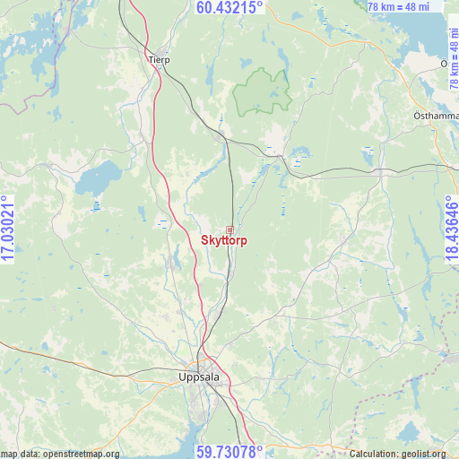
Skyttorp GPS coordinates[2]
60° 4' 59.988" North, 17° 43' 59.988" East
| Map corner | latitude | longitude |
|---|---|---|
| Upper-left | 60.43215°, | 17.03021° |
| Center: | 60.08333°, | 17.73333° |
| Lower-right: | 59.73078°, | 18.43646° |
| Map W x H: | 78×78 km | = 48.5×48.5mi |
| max Lat: | 67.85572° ⇑25.6% North |
| Skyttorp: | 60.08333° |
| min Lat: | ⇓74.4% South 55.34337° |
| min Long | Skyttorp | max Long |
| 11.1712° | 17.73333° | 24.13676° |
| W 81.9%⇐ | ⇒18.1% E |
Elevation
Elevation of Skyttorp is 27 m = 89 ft, and this is 55.6 m = 182 ft below average elevation for this country.
| Max E: |
663 m = 2175 ft | 67.8% |
| Avg. | 82.6 m = 271 ft | |
| Skyttorp | 27 m = 89 ft | |
Min E: |
-1 m = -3 ft | 32.2% |
See also: Sweden elevation on elevation.city.
Geographical zone
Skyttorp is located in North temperate zone (between Tropic of Cancer and the Arctic Circle). Distance of this North polar circle is 720.5 km =447.7 mi to North.| Distance of | km | miles | from Skyttorp |
|---|---|---|---|
| North Pole | 3326.4 | 2066.9 | to North |
| Arctic Circle | 720.5 | 447.7 | to North |
| Tropic Cancer | 4074.7 | 2531.9 | to South |
| Equator | 6680.6 | 4151.1 | to South |


Nearby cities:
15 places around Skyttorp: (largest is in red/bold)
• Alunda
19.5 km =12.1 mi,  95°
95°
• Björklinge
11.7 km =7.3 mi,  239°
239°
• Bälinge
18.5 km =11.5 mi,  216°
216°
• Gamla Uppsala
21.3 km =13.2 mi,  195°
195°
• Gåvsta
17.5 km =10.9 mi,  152°
152°
• Karby
11.1 km =6.9 mi,  311°
311°
• Länna
26.5 km =16.5 mi, 152°
• Lövstalöt
16.4 km =10.2 mi,  211°
211°
• Månkarbo
22 km =13.7 mi,  317°
317°
• Storvreta
13.9 km =8.6 mi,  186°
186°
• Tobo
19.9 km =12.4 mi,  347°
347°
• Uppsala
25.5 km =15.8 mi, 191°
• Vattholma
7.4 km =4.6 mi,  180°
180°
• Örbyhus
15.7 km =9.8 mi, 353°
• Österbybruk
15.9 km =9.9 mi,  35°
35°
Sources, notices
• [Note1] Compared only with cities in Sweden existing in our database
• [Src1] Map data: © OpenStreetMap contributors (CC-BY-SA)
• [Src2] Other city data from geonames.org with taken over terms of usage.
• [Src3] Geographical zone / Annual Mean Temperature by Robert A. Rohde @ Wikipedia
