Timmele geodata
Timmele (Västra Götaland) is a populated place; located in Sweden in Europe/Stockholm (GMT+2) time zone. With population of 788 people, there are 974 cities with bigger population in this country. Compared to other cities in Sweden, 62.9% of cities are located further ↑North; 72.6% of cities are located further →East and 87.9% of cities have lower elevation than Timmele. Note1


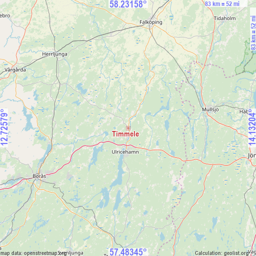
Timmele GPS coordinates[2]
57° 51' 34.056" North, 13° 25' 44.076" East
| Map corner | latitude | longitude |
|---|---|---|
| Upper-left | 58.23158°, | 12.72579° |
| Center: | 57.85946°, | 13.42891° |
| Lower-right: | 57.48345°, | 14.13204° |
| Map W x H: | 83.2×83.2 km | = 51.7×51.7mi |
| max Lat: | 67.85572° ⇑62.9% North |
| Timmele: | 57.85946° |
| min Lat: | ⇓37.1% South 55.34337° |
| min Long | Timmele | max Long |
| 11.1712° | 13.42891° | 24.13676° |
| W 27.4%⇐ | ⇒72.6% E |
Elevation
Elevation of Timmele is 183 m = 600 ft, and this is 100.4 m = 329 ft above average elevation for this country.
| Max E: |
663 m = 2175 ft | 12.1% |
| Timmele | 183 m 600 ft | |
| Avg. | 82.6 m = 271 ft | |
Min E: |
-1 m = -3 ft | 87.9% |
See also: Sweden elevation on elevation.city.
Geographical zone
Timmele is located in North temperate zone (between Tropic of Cancer and the Arctic Circle). Distance of this North polar circle is 967.8 km =601.4 mi to North.| Distance of | km | miles | from Timmele |
|---|---|---|---|
| North Pole | 3573.7 | 2220.6 | to North |
| Arctic Circle | 967.8 | 601.4 | to North |
| Tropic Cancer | 3827.4 | 2378.2 | to South |
| Equator | 6433.4 | 3997.5 | to South |


Nearby cities:
15 places around Timmele: (largest is in red/bold)
• Annelund
25.4 km =15.8 mi,  304°
304°
• Blidsberg
8.8 km =5.5 mi,  21°
21°
• Bottnaryd
25.5 km =15.8 mi,  112°
112°
• Dalsjöfors
25.9 km =16.1 mi,  232°
232°
• Dalum
4.8 km =3 mi,  25°
25°
• Fristad
25.1 km =15.6 mi,  261°
261°
• Gällstad
21.4 km =13.3 mi,  179°
179°
• Hökerum
8.8 km =5.5 mi, 256°
• Kinnarp
24.9 km =15.5 mi,  12°
12°
• Ljung
26.2 km =16.3 mi, 302°
• Sandhem
17.8 km =11.1 mi, 10°
• Sandhem
24.2 km =15 mi,  55°
55°
• Ulricehamn
7.6 km =4.7 mi,  186°
186°
• Vegby
19.8 km =12.3 mi, 187°
• Åsarp
20 km =12.4 mi, 23°
Sources, notices
• [Note1] Compared only with cities in Sweden existing in our database
• [Src1] Map data: © OpenStreetMap contributors (CC-BY-SA)
• [Src2] Other city data from geonames.org with taken over terms of usage.
• [Src3] Geographical zone / Annual Mean Temperature by Robert A. Rohde @ Wikipedia
