Roma geodata
Roma (Gotland) is a populated place; located in Sweden in Europe/Stockholm (GMT+2) time zone. With population of 905 people, there are 881 cities with bigger population in this country. Compared to other cities in Sweden, 71.5% of cities are located further ↑North; 90.6% of cities are located further ←West and 62.9% of cities have higher elevation than Roma. Note1


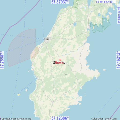
Roma GPS coordinates[2]
57° 30' 12.852" North, 18° 27' 32.364" East
| Map corner | latitude | longitude |
|---|---|---|
| Upper-left | 57.87937°, | 17.75587° |
| Center: | 57.50357°, | 18.45899° |
| Lower-right: | 57.12386°, | 19.16212° |
| Map W x H: | 84×84 km | = 52.2×52.2mi |
| max Lat: | 67.85572° ⇑71.5% North |
| Roma: | 57.50357° |
| min Lat: | ⇓28.5% South 55.34337° |
| min Long | Roma | max Long |
| 11.1712° | 18.45899° | 24.13676° |
| W 90.6%⇐ | ⇒9.4% E |
Elevation
Elevation of Roma is 32 m = 105 ft, and this is 50.6 m = 166 ft below average elevation for this country.
| Max E: |
663 m = 2175 ft | 62.9% |
| Avg. | 82.6 m = 271 ft | |
| Roma | 32 m = 105 ft | |
Min E: |
-1 m = -3 ft | 37.1% |
See also: Sweden elevation on elevation.city.
Geographical zone
Roma is located in North temperate zone (between Tropic of Cancer and the Arctic Circle). Distance of this North polar circle is 1007.4 km =626 mi to North.| Distance of | km | miles | from Roma |
|---|---|---|---|
| North Pole | 3613.3 | 2245.2 | to North |
| Arctic Circle | 1007.4 | 626 | to North |
| Tropic Cancer | 3787.9 | 2353.7 | to South |
| Equator | 6393.8 | 3972.9 | to South |


Nearby cities:
15 places around Roma: (largest is in red/bold)
• Figeholm
115.3 km =71.6 mi,  262°
262°
• Fårösund
53.3 km =33.1 mi,  42°
42°
• Gunnebo
117.1 km =72.8 mi,  281°
281°
• Hemse
30 km =18.6 mi,  189°
189°
• Klintehamn
20.1 km =12.5 mi,  229°
229°
• Löttorp
96.2 km =59.8 mi,  247°
247°
• Oskarshamn
123.4 km =76.7 mi, 257°
• Piperskärr
113 km =70.2 mi,  285°
285°
• Påskallavik
126.2 km =78.4 mi, 252°
• Slite
30.3 km =18.8 mi, 42°
• Tofta
19.5 km =12.1 mi,  265°
265°
• Vibble
16.5 km =10.3 mi,  312°
312°
• Visby
18.1 km =11.2 mi,  327°
327°
• Västervik
112.1 km =69.7 mi, 284°
• Österby
31.4 km =19.5 mi, 40°
Sources, notices
• [Note1] Compared only with cities in Sweden existing in our database
• [Src1] Map data: © OpenStreetMap contributors (CC-BY-SA)
• [Src2] Other city data from geonames.org with taken over terms of usage.
• [Src3] Geographical zone / Annual Mean Temperature by Robert A. Rohde @ Wikipedia
