Västervik geodata
Västervik (Kalmar) is a seat of a second-order administrative division; located in Sweden in Europe/Stockholm (GMT+2) time zone. With population of 21,178 people, there are 75 cities with bigger population in this country. Compared to other cities in Sweden, 65.6% of cities are located further ↑North; 70.8% of cities are located further ←West and 87.5% of cities have higher elevation than Västervik. Note1


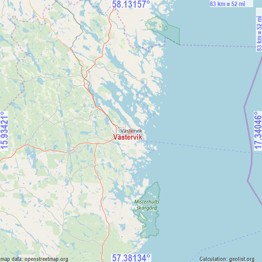
Västervik GPS coordinates[2]
57° 45' 30.24" North, 16° 38' 14.388" East
| Map corner | latitude | longitude |
|---|---|---|
| Upper-left | 58.13157°, | 15.93421° |
| Center: | 57.7584°, | 16.63733° |
| Lower-right: | 57.38134°, | 17.34046° |
| Map W x H: | 83.4×83.4 km | = 51.8×51.8mi |
| max Lat: | 67.85572° ⇑65.6% North |
| Västervik: | 57.7584° |
| min Lat: | ⇓34.4% South 55.34337° |
| min Long | Västervik | max Long |
| 11.1712° | 16.63733° | 24.13676° |
| W 70.8%⇐ | ⇒29.2% E |
Elevation
Elevation of Västervik is 11 m = 36 ft, and this is 71.6 m = 235 ft below average elevation for this country.
| Max E: |
663 m = 2175 ft | 87.5% |
| Avg. | 82.6 m = 271 ft | |
| Västervik | 11 m = 36 ft | |
Min E: |
-1 m = -3 ft | 12.5% |
See also: Sweden elevation on elevation.city.
Geographical zone
Västervik is located in North temperate zone (between Tropic of Cancer and the Arctic Circle). Distance of this North polar circle is 979 km =608.3 mi to North.| Distance of | km | miles | from Västervik |
|---|---|---|---|
| North Pole | 3584.9 | 2227.6 | to North |
| Arctic Circle | 979 | 608.3 | to North |
| Tropic Cancer | 3816.2 | 2371.3 | to South |
| Equator | 6422.1 | 3990.5 | to South |


Nearby cities:
15 places around Västervik: (largest is in red/bold)
• Ankarsrum
19.2 km =11.9 mi,  249°
249°
• Figeholm
43.9 km =27.3 mi,  186°
186°
• Gamleby
20.5 km =12.7 mi,  317°
317°
• Gullringen
55.8 km =34.7 mi,  274°
274°
• Gunnebo
7.7 km =4.8 mi,  233°
233°
• Horn
50.1 km =31.1 mi,  288°
288°
• Hultsfred
56 km =34.8 mi,  237°
237°
• Kristdala
47.4 km =29.5 mi,  212°
212°
• Oskarshamn
56.1 km =34.9 mi, 191°
• Piperskärr
2.8 km =1.7 mi,  354°
354°
• Storebro
50.7 km =31.5 mi, 247°
• Södra Vi
50.1 km =31.1 mi, 267°
• Valdemarsvik
49.5 km =30.8 mi,  357°
357°
• Vimmerby
47.6 km =29.6 mi,  257°
257°
• Överum
31.9 km =19.8 mi, 323°
Sources, notices
• [Note1] Compared only with cities in Sweden existing in our database
• [Src1] Map data: © OpenStreetMap contributors (CC-BY-SA)
• [Src2] Other city data from geonames.org with taken over terms of usage.
• [Src3] Geographical zone / Annual Mean Temperature by Robert A. Rohde @ Wikipedia
