Klintehamn geodata
Klintehamn (Gotland) is a populated place; located in Sweden in Europe/Stockholm (GMT+2) time zone. With population of 1,490 people, there are 660 cities with bigger population in this country. Compared to other cities in Sweden, 73.4% of cities are located further ↑North; 88.2% of cities are located further ←West and 93.9% of cities have higher elevation than Klintehamn. Note1


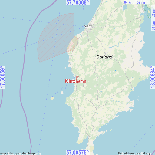
Klintehamn GPS coordinates[2]
57° 23' 12.012" North, 18° 12' 13.356" East
| Map corner | latitude | longitude |
|---|---|---|
| Upper-left | 57.76368°, | 17.50059° |
| Center: | 57.38667°, | 18.20371° |
| Lower-right: | 57.00575°, | 18.90684° |
| Map W x H: | 84.3×84.3 km | = 52.4×52.4mi |
| max Lat: | 67.85572° ⇑73.4% North |
| Klintehamn: | 57.38667° |
| min Lat: | ⇓26.6% South 55.34337° |
| min Long | Klintehamn | max Long |
| 11.1712° | 18.20371° | 24.13676° |
| W 88.2%⇐ | ⇒11.8% E |
Elevation
Elevation of Klintehamn is 6 m = 20 ft, and this is 76.6 m = 251 ft below average elevation for this country.
| Max E: |
663 m = 2175 ft | 93.9% |
| Avg. | 82.6 m = 271 ft | |
| Klintehamn | 6 m = 20 ft | |
Min E: |
-1 m = -3 ft | 6.1% |
See also: Sweden elevation on elevation.city.
Geographical zone
Klintehamn is located in North temperate zone (between Tropic of Cancer and the Arctic Circle). Distance of this North polar circle is 1020.4 km =634 mi to North.| Distance of | km | miles | from Klintehamn |
|---|---|---|---|
| North Pole | 3626.3 | 2253.3 | to North |
| Arctic Circle | 1020.4 | 634 | to North |
| Tropic Cancer | 3774.9 | 2345.6 | to South |
| Equator | 6380.8 | 3964.8 | to South |


Nearby cities:
15 places around Klintehamn: (largest is in red/bold)
• Figeholm
99.2 km =61.6 mi,  268°
268°
• Fårösund
73.2 km =45.5 mi,  44°
44°
• Gunnebo
106.2 km =66 mi,  290°
290°
• Hemse
19.5 km =12.1 mi,  148°
148°
• Löttorp
77.3 km =48 mi,  251°
251°
• Oskarshamn
106.2 km =66 mi,  262°
262°
• Piperskärr
103.5 km =64.3 mi,  295°
295°
• Påskallavik
108.2 km =67.2 mi, 256°
• Roma
20.1 km =12.5 mi,  49°
49°
• Slite
50.3 km =31.3 mi, 45°
• Tofta
12.2 km =7.6 mi,  340°
340°
• Vibble
24.4 km =15.2 mi,  7°
7°
• Visby
28.8 km =17.9 mi, 11°
• Västervik
102.1 km =63.4 mi, 293°
• Österby
51.3 km =31.9 mi, 44°
Sources, notices
• [Note1] Compared only with cities in Sweden existing in our database
• [Src1] Map data: © OpenStreetMap contributors (CC-BY-SA)
• [Src2] Other city data from geonames.org with taken over terms of usage.
• [Src3] Geographical zone / Annual Mean Temperature by Robert A. Rohde @ Wikipedia
